You are here: Home > Network List > US - United States National Seismic Network Stations List
> Station AMTX Amarillo, Texas, USA > Earthquake Result Viewer
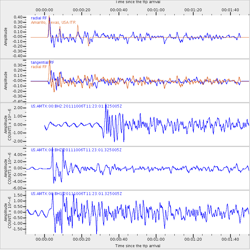
AMTX Amarillo, Texas, USA - Earthquake Result Viewer
*The percent match for this event was below the threshold and hence no stack was calculated.
| Earthquake location: |
Salta Province, Argentina |
| Earthquake latitude/longitude: |
-24.2/-64.2 |
| Earthquake time(UTC): |
2011/10/06 (279) 11:12:30 GMT |
| Earthquake Depth: |
15 km |
| Earthquake Magnitude: |
6.5 MB, 5.7 MS, 6.1 MW, 5.9 MW |
| Earthquake Catalog/Contributor: |
WHDF/NEIC |
|
| Network: |
US United States National Seismic Network |
| Station: |
AMTX Amarillo, Texas, USA |
| Lat/Lon: |
34.53 N/101.41 W |
| Elevation: |
1010 m |
|
| Distance: |
68.2 deg |
| Az: |
327.496 deg |
| Baz: |
143.527 deg |
| Ray Param: |
$rayparam |
*The percent match for this event was below the threshold and hence was not used in the summary stack. |
|
| Radial Match: |
72.14338 % |
| Radial Bump: |
400 |
| Transverse Match: |
74.561264 % |
| Transverse Bump: |
400 |
| SOD ConfigId: |
558545 |
| Insert Time: |
2013-09-19 03:56:09.195 +0000 |
| GWidth: |
2.5 |
| Max Bumps: |
400 |
| Tol: |
0.001 |
|
Signal To Noise
| Channel | StoN | STA | LTA |
| US:AMTX:00:BHZ:20111006T11:23:01.325005Z | 12.532989 | 1.9114846E-6 | 1.5251626E-7 |
| US:AMTX:00:BH1:20111006T11:23:01.325005Z | 2.2574356 | 5.684047E-7 | 2.5179222E-7 |
| US:AMTX:00:BH2:20111006T11:23:01.325005Z | 2.7323663 | 5.164963E-7 | 1.8902892E-7 |
| Arrivals |
| Ps | |
| PpPs | |
| PsPs/PpSs | |


