You are here: Home > Network List > US - United States National Seismic Network Stations List
> Station DGMT Dagmar, Montana, USA > Earthquake Result Viewer
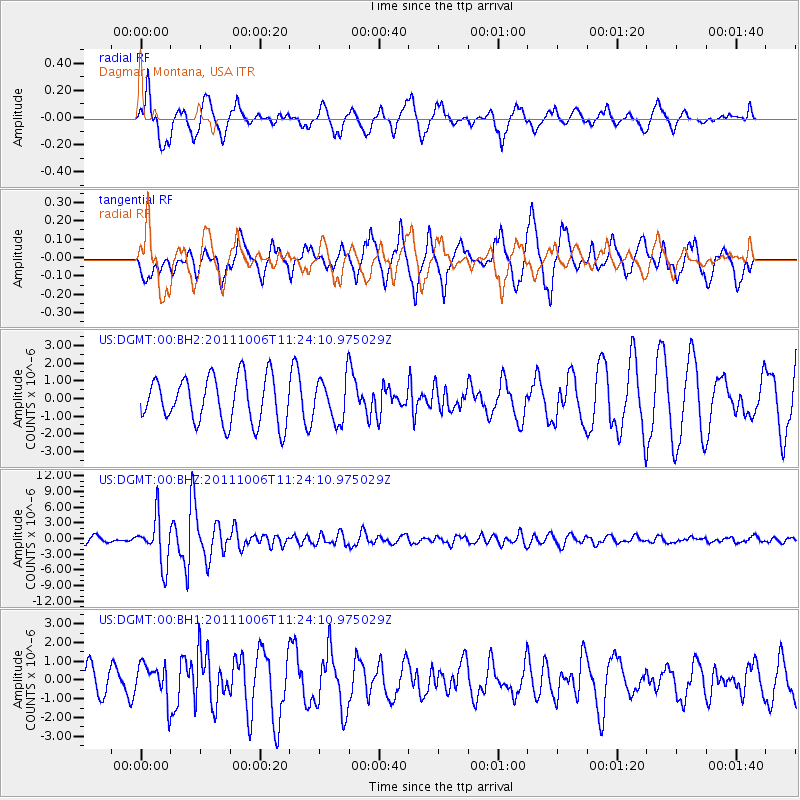
DGMT Dagmar, Montana, USA - Earthquake Result Viewer
*The percent match for this event was below the threshold and hence no stack was calculated.
| Earthquake location: |
Salta Province, Argentina |
| Earthquake latitude/longitude: |
-24.2/-64.2 |
| Earthquake time(UTC): |
2011/10/06 (279) 11:12:30 GMT |
| Earthquake Depth: |
15 km |
| Earthquake Magnitude: |
6.5 MB, 5.7 MS, 6.1 MW, 5.9 MW |
| Earthquake Catalog/Contributor: |
WHDF/NEIC |
|
| Network: |
US United States National Seismic Network |
| Station: |
DGMT Dagmar, Montana, USA |
| Lat/Lon: |
48.47 N/104.20 W |
| Elevation: |
0.0 m |
|
| Distance: |
80.7 deg |
| Az: |
334.325 deg |
| Baz: |
143.516 deg |
| Ray Param: |
$rayparam |
*The percent match for this event was below the threshold and hence was not used in the summary stack. |
|
| Radial Match: |
67.70734 % |
| Radial Bump: |
400 |
| Transverse Match: |
62.53655 % |
| Transverse Bump: |
382 |
| SOD ConfigId: |
558545 |
| Insert Time: |
2013-09-19 03:56:34.629 +0000 |
| GWidth: |
2.5 |
| Max Bumps: |
400 |
| Tol: |
0.001 |
|
Signal To Noise
| Channel | StoN | STA | LTA |
| US:DGMT:00:BHZ:20111006T11:24:10.975029Z | 10.466525 | 4.464413E-6 | 4.2654202E-7 |
| US:DGMT:00:BH1:20111006T11:24:10.975029Z | 0.93578064 | 9.664753E-7 | 1.0328012E-6 |
| US:DGMT:00:BH2:20111006T11:24:10.975029Z | 0.923517 | 1.204867E-6 | 1.3046506E-6 |
| Arrivals |
| Ps | |
| PpPs | |
| PsPs/PpSs | |


