You are here: Home > Network List > US - United States National Seismic Network Stations List
> Station HAWA Hanford, Washington, USA > Earthquake Result Viewer
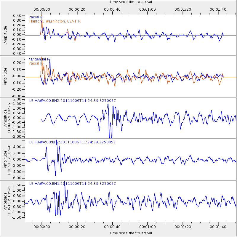
HAWA Hanford, Washington, USA - Earthquake Result Viewer
*The percent match for this event was below the threshold and hence no stack was calculated.
| Earthquake location: |
Salta Province, Argentina |
| Earthquake latitude/longitude: |
-24.2/-64.2 |
| Earthquake time(UTC): |
2011/10/06 (279) 11:12:30 GMT |
| Earthquake Depth: |
15 km |
| Earthquake Magnitude: |
6.5 MB, 5.7 MS, 6.1 MW, 5.9 MW |
| Earthquake Catalog/Contributor: |
WHDF/NEIC |
|
| Network: |
US United States National Seismic Network |
| Station: |
HAWA Hanford, Washington, USA |
| Lat/Lon: |
46.39 N/119.53 W |
| Elevation: |
364 m |
|
| Distance: |
86.2 deg |
| Az: |
325.224 deg |
| Baz: |
131.182 deg |
| Ray Param: |
$rayparam |
*The percent match for this event was below the threshold and hence was not used in the summary stack. |
|
| Radial Match: |
62.10908 % |
| Radial Bump: |
400 |
| Transverse Match: |
67.07878 % |
| Transverse Bump: |
400 |
| SOD ConfigId: |
558545 |
| Insert Time: |
2013-09-19 03:56:59.330 +0000 |
| GWidth: |
2.5 |
| Max Bumps: |
400 |
| Tol: |
0.001 |
|
Signal To Noise
| Channel | StoN | STA | LTA |
| US:HAWA:00:BHZ:20111006T11:24:39.325005Z | 5.171095 | 1.8516224E-6 | 3.5807165E-7 |
| US:HAWA:00:BH1:20111006T11:24:39.325005Z | 2.2114363 | 4.5097335E-7 | 2.039278E-7 |
| US:HAWA:00:BH2:20111006T11:24:39.325005Z | 1.6179471 | 5.165853E-7 | 3.192844E-7 |
| Arrivals |
| Ps | |
| PpPs | |
| PsPs/PpSs | |


