You are here: Home > Network List > TA - USArray Transportable Network (new EarthScope stations) Stations List
> Station M61A Granite Springs, NY, USA > Earthquake Result Viewer
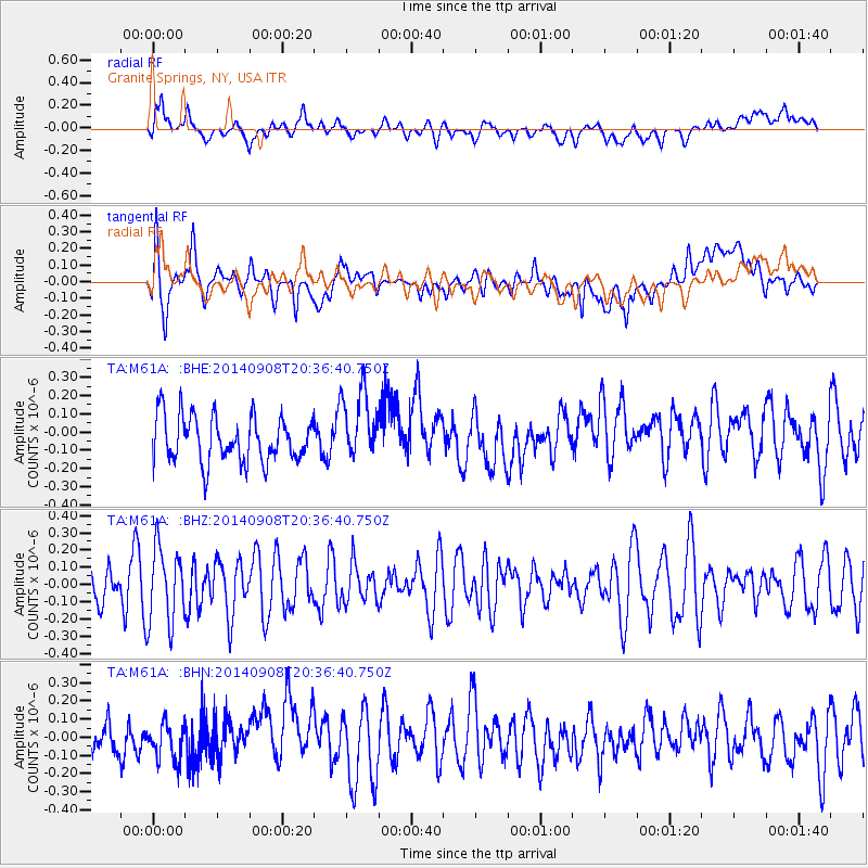
M61A Granite Springs, NY, USA - Earthquake Result Viewer
*The percent match for this event was below the threshold and hence no stack was calculated.
| Earthquake location: |
Near Coast Of Guerrero, Mexico |
| Earthquake latitude/longitude: |
16.2/-98.3 |
| Earthquake time(UTC): |
2014/09/08 (251) 20:30:39 GMT |
| Earthquake Depth: |
11 km |
| Earthquake Magnitude: |
4.9 MW |
| Earthquake Catalog/Contributor: |
ISC/ISC |
|
| Network: |
TA USArray Transportable Network (new EarthScope stations) |
| Station: |
M61A Granite Springs, NY, USA |
| Lat/Lon: |
41.31 N/73.77 W |
| Elevation: |
190 m |
|
| Distance: |
32.7 deg |
| Az: |
35.289 deg |
| Baz: |
227.446 deg |
| Ray Param: |
$rayparam |
*The percent match for this event was below the threshold and hence was not used in the summary stack. |
|
| Radial Match: |
58.347458 % |
| Radial Bump: |
400 |
| Transverse Match: |
52.038834 % |
| Transverse Bump: |
400 |
| SOD ConfigId: |
3390531 |
| Insert Time: |
2019-04-13 22:31:21.034 +0000 |
| GWidth: |
2.5 |
| Max Bumps: |
400 |
| Tol: |
0.001 |
|
Signal To Noise
| Channel | StoN | STA | LTA |
| TA:M61A: :BHZ:20140908T20:36:40.750Z | 1.7613398 | 2.2095588E-7 | 1.2544761E-7 |
| TA:M61A: :BHN:20140908T20:36:40.750Z | 0.5545775 | 9.7509876E-8 | 1.7582732E-7 |
| TA:M61A: :BHE:20140908T20:36:40.750Z | 1.5306287 | 1.9225428E-7 | 1.2560479E-7 |
| Arrivals |
| Ps | |
| PpPs | |
| PsPs/PpSs | |


