You are here: Home > Network List > UW - Pacific Northwest Regional Seismic Network Stations List
> Station HOOD Mt Hood Meadows, OR CREST BB SMO > Earthquake Result Viewer
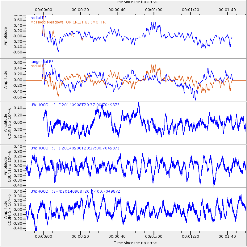
HOOD Mt Hood Meadows, OR CREST BB SMO - Earthquake Result Viewer
*The percent match for this event was below the threshold and hence no stack was calculated.
| Earthquake location: |
Near Coast Of Guerrero, Mexico |
| Earthquake latitude/longitude: |
16.2/-98.3 |
| Earthquake time(UTC): |
2014/09/08 (251) 20:30:39 GMT |
| Earthquake Depth: |
11 km |
| Earthquake Magnitude: |
4.9 MW |
| Earthquake Catalog/Contributor: |
ISC/ISC |
|
| Network: |
UW Pacific Northwest Regional Seismic Network |
| Station: |
HOOD Mt Hood Meadows, OR CREST BB SMO |
| Lat/Lon: |
45.32 N/121.65 W |
| Elevation: |
1520 m |
|
| Distance: |
35.0 deg |
| Az: |
330.774 deg |
| Baz: |
138.334 deg |
| Ray Param: |
$rayparam |
*The percent match for this event was below the threshold and hence was not used in the summary stack. |
|
| Radial Match: |
56.124233 % |
| Radial Bump: |
400 |
| Transverse Match: |
54.205074 % |
| Transverse Bump: |
400 |
| SOD ConfigId: |
3390531 |
| Insert Time: |
2019-04-13 22:31:41.329 +0000 |
| GWidth: |
2.5 |
| Max Bumps: |
400 |
| Tol: |
0.001 |
|
Signal To Noise
| Channel | StoN | STA | LTA |
| UW:HOOD: :BHZ:20140908T20:37:00.704987Z | 0.6923325 | 8.491296E-8 | 1.2264766E-7 |
| UW:HOOD: :BHN:20140908T20:37:00.704987Z | 0.55719954 | 1.6202402E-7 | 2.9078276E-7 |
| UW:HOOD: :BHE:20140908T20:37:00.704987Z | 2.8181088 | 4.2886361E-7 | 1.5218136E-7 |
| Arrivals |
| Ps | |
| PpPs | |
| PsPs/PpSs | |


