You are here: Home > Network List > CN - Canadian National Seismograph Network Stations List
> Station INK INUVIK, NT, CANADA.ANADA > Earthquake Result Viewer
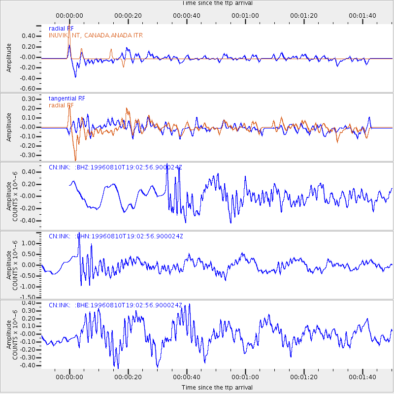
INK INUVIK, NT, CANADA.ANADA - Earthquake Result Viewer
*The percent match for this event was below the threshold and hence no stack was calculated.
| Earthquake location: |
Eastern Honshu, Japan |
| Earthquake latitude/longitude: |
38.9/140.6 |
| Earthquake time(UTC): |
1996/08/10 (223) 18:54:11 GMT |
| Earthquake Depth: |
10 km |
| Earthquake Magnitude: |
5.7 MB, 5.1 MS |
| Earthquake Catalog/Contributor: |
WHDF/NEIC |
|
| Network: |
CN Canadian National Seismograph Network |
| Station: |
INK INUVIK, NT, CANADA.ANADA |
| Lat/Lon: |
68.31 N/133.52 W |
| Elevation: |
40 m |
|
| Distance: |
53.0 deg |
| Az: |
27.663 deg |
| Baz: |
283.114 deg |
| Ray Param: |
$rayparam |
*The percent match for this event was below the threshold and hence was not used in the summary stack. |
|
| Radial Match: |
56.625805 % |
| Radial Bump: |
400 |
| Transverse Match: |
37.0602 % |
| Transverse Bump: |
400 |
| SOD ConfigId: |
4480 |
| Insert Time: |
2010-02-27 06:27:40.151 +0000 |
| GWidth: |
2.5 |
| Max Bumps: |
400 |
| Tol: |
0.001 |
|
Signal To Noise
| Channel | StoN | STA | LTA |
| CN:INK: :BHN:19960810T19:02:56.900024Z | 4.219477 | 5.567508E-7 | 1.3194781E-7 |
| CN:INK: :BHE:19960810T19:02:56.900024Z | 0.61452246 | 6.7367075E-8 | 1.0962508E-7 |
| CN:INK: :BHZ:19960810T19:02:56.900024Z | 1.0916355 | 1.704709E-7 | 1.5616102E-7 |
| Arrivals |
| Ps | |
| PpPs | |
| PsPs/PpSs | |


