You are here: Home > Network List > US - United States National Seismic Network Stations List
> Station MNTX Cornudas Mountains, Texas, USA > Earthquake Result Viewer
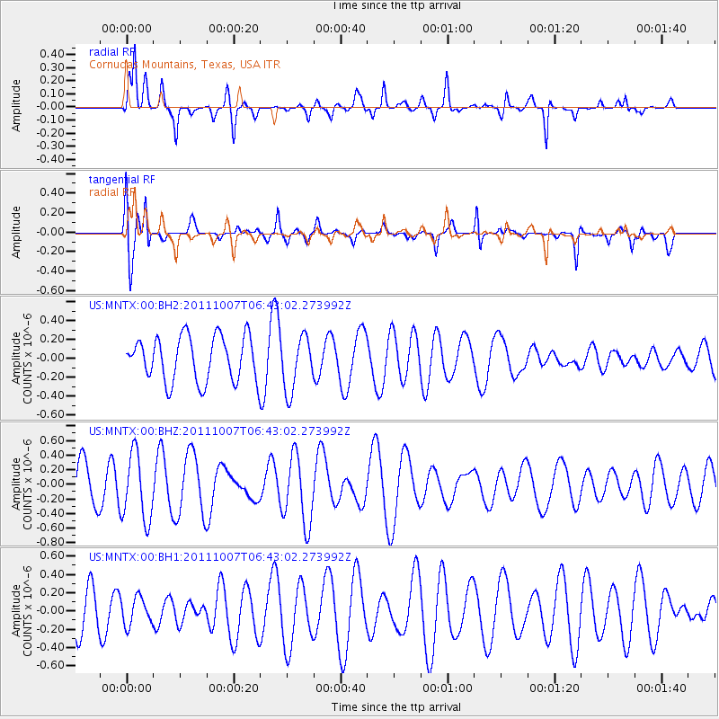
MNTX Cornudas Mountains, Texas, USA - Earthquake Result Viewer
*The percent match for this event was below the threshold and hence no stack was calculated.
| Earthquake location: |
Southeast Of Loyalty Islands |
| Earthquake latitude/longitude: |
-22.2/171.2 |
| Earthquake time(UTC): |
2011/10/07 (280) 06:30:19 GMT |
| Earthquake Depth: |
119 km |
| Earthquake Magnitude: |
5.6 MW |
| Earthquake Catalog/Contributor: |
NEIC PDE/NEIC PDE-M |
|
| Network: |
US United States National Seismic Network |
| Station: |
MNTX Cornudas Mountains, Texas, USA |
| Lat/Lon: |
31.70 N/105.38 W |
| Elevation: |
404 m |
|
| Distance: |
96.1 deg |
| Az: |
58.376 deg |
| Baz: |
247.776 deg |
| Ray Param: |
$rayparam |
*The percent match for this event was below the threshold and hence was not used in the summary stack. |
|
| Radial Match: |
58.84043 % |
| Radial Bump: |
338 |
| Transverse Match: |
63.765594 % |
| Transverse Bump: |
400 |
| SOD ConfigId: |
558545 |
| Insert Time: |
2013-09-19 03:59:32.046 +0000 |
| GWidth: |
2.5 |
| Max Bumps: |
400 |
| Tol: |
0.001 |
|
Signal To Noise
| Channel | StoN | STA | LTA |
| US:MNTX:00:BHZ:20111007T06:43:02.273992Z | 1.7473482 | 4.618076E-7 | 2.6429055E-7 |
| US:MNTX:00:BH1:20111007T06:43:02.273992Z | 0.6287433 | 1.518433E-7 | 2.4150285E-7 |
| US:MNTX:00:BH2:20111007T06:43:02.273992Z | 1.2298882 | 2.8949236E-7 | 2.3538104E-7 |
| Arrivals |
| Ps | |
| PpPs | |
| PsPs/PpSs | |


