You are here: Home > Network List > IU - Global Seismograph Network (GSN - IRIS/USGS) Stations List
> Station GUMO Guam, Mariana Islands > Earthquake Result Viewer
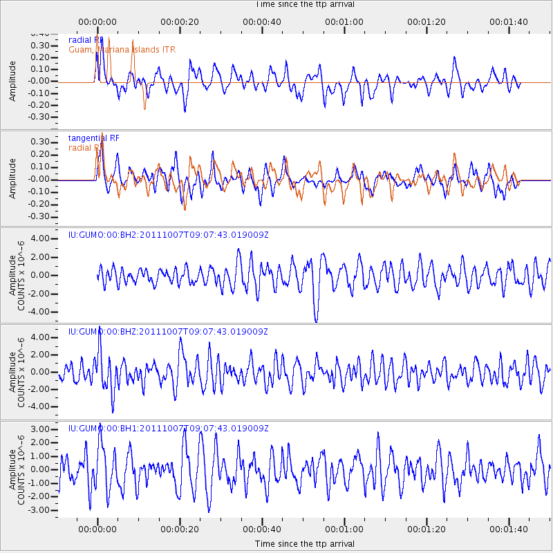
GUMO Guam, Mariana Islands - Earthquake Result Viewer
*The percent match for this event was below the threshold and hence no stack was calculated.
| Earthquake location: |
South Of Kermadec Islands |
| Earthquake latitude/longitude: |
-32.5/-179.0 |
| Earthquake time(UTC): |
2011/10/07 (280) 08:58:28 GMT |
| Earthquake Depth: |
36 km |
| Earthquake Magnitude: |
5.9 MB, 5.8 MS, 6.1 MW, 6.1 MW |
| Earthquake Catalog/Contributor: |
WHDF/NEIC |
|
| Network: |
IU Global Seismograph Network (GSN - IRIS/USGS) |
| Station: |
GUMO Guam, Mariana Islands |
| Lat/Lon: |
13.59 N/144.87 E |
| Elevation: |
170 m |
|
| Distance: |
57.4 deg |
| Az: |
317.153 deg |
| Baz: |
143.78 deg |
| Ray Param: |
$rayparam |
*The percent match for this event was below the threshold and hence was not used in the summary stack. |
|
| Radial Match: |
62.093826 % |
| Radial Bump: |
400 |
| Transverse Match: |
46.23789 % |
| Transverse Bump: |
368 |
| SOD ConfigId: |
558545 |
| Insert Time: |
2013-09-19 04:00:28.755 +0000 |
| GWidth: |
2.5 |
| Max Bumps: |
400 |
| Tol: |
0.001 |
|
Signal To Noise
| Channel | StoN | STA | LTA |
| IU:GUMO:00:BHZ:20111007T09:07:43.019009Z | 2.5905857 | 2.3619161E-6 | 9.117306E-7 |
| IU:GUMO:00:BH1:20111007T09:07:43.019009Z | 1.9717896 | 1.6909933E-6 | 8.575932E-7 |
| IU:GUMO:00:BH2:20111007T09:07:43.019009Z | 2.019775 | 1.4507889E-6 | 7.1829237E-7 |
| Arrivals |
| Ps | |
| PpPs | |
| PsPs/PpSs | |


