You are here: Home > Network List > CN - Canadian National Seismograph Network Stations List
> Station INK INUVIK, NT, CANADA.ANADA > Earthquake Result Viewer
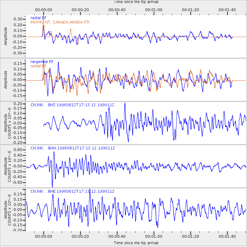
INK INUVIK, NT, CANADA.ANADA - Earthquake Result Viewer
*The percent match for this event was below the threshold and hence no stack was calculated.
| Earthquake location: |
Southern Molucca Sea |
| Earthquake latitude/longitude: |
-0.3/125.1 |
| Earthquake time(UTC): |
1996/08/12 (225) 17:00:27 GMT |
| Earthquake Depth: |
42 km |
| Earthquake Magnitude: |
5.7 MB, 5.5 MS, 6.1 UNKNOWN, 6.0 MW |
| Earthquake Catalog/Contributor: |
WHDF/NEIC |
|
| Network: |
CN Canadian National Seismograph Network |
| Station: |
INK INUVIK, NT, CANADA.ANADA |
| Lat/Lon: |
68.31 N/133.52 W |
| Elevation: |
40 m |
|
| Distance: |
94.5 deg |
| Az: |
21.443 deg |
| Baz: |
280.492 deg |
| Ray Param: |
$rayparam |
*The percent match for this event was below the threshold and hence was not used in the summary stack. |
|
| Radial Match: |
55.734226 % |
| Radial Bump: |
383 |
| Transverse Match: |
61.581776 % |
| Transverse Bump: |
362 |
| SOD ConfigId: |
4480 |
| Insert Time: |
2010-02-27 06:27:51.697 +0000 |
| GWidth: |
2.5 |
| Max Bumps: |
400 |
| Tol: |
0.001 |
|
Signal To Noise
| Channel | StoN | STA | LTA |
| CN:INK: :BHN:19960812T17:13:12.199011Z | 3.8150134 | 2.1160308E-7 | 5.5465883E-8 |
| CN:INK: :BHE:19960812T17:13:12.199011Z | 1.6270294 | 5.6011135E-8 | 3.4425398E-8 |
| CN:INK: :BHZ:19960812T17:13:12.199011Z | 2.0338163 | 6.673648E-8 | 3.281343E-8 |
| Arrivals |
| Ps | |
| PpPs | |
| PsPs/PpSs | |


