You are here: Home > Network List > US - United States National Seismic Network Stations List
> Station DGMT Dagmar, Montana, USA > Earthquake Result Viewer
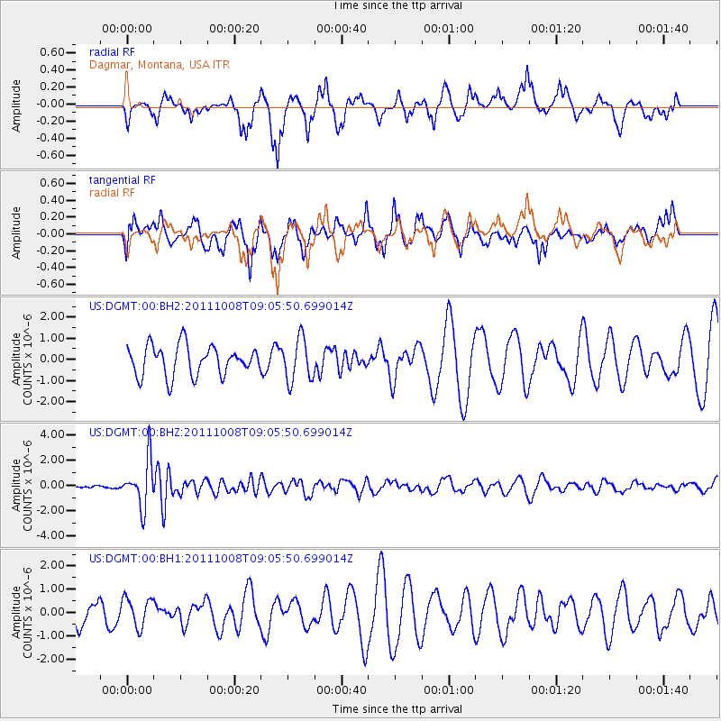
DGMT Dagmar, Montana, USA - Earthquake Result Viewer
*The percent match for this event was below the threshold and hence no stack was calculated.
| Earthquake location: |
Tonga Islands |
| Earthquake latitude/longitude: |
-20.6/-173.2 |
| Earthquake time(UTC): |
2011/10/08 (281) 08:53:11 GMT |
| Earthquake Depth: |
6.0 km |
| Earthquake Magnitude: |
6.1 MB, 5.6 MS, 5.9 MW, 5.9 MW |
| Earthquake Catalog/Contributor: |
WHDF/NEIC |
|
| Network: |
US United States National Seismic Network |
| Station: |
DGMT Dagmar, Montana, USA |
| Lat/Lon: |
48.47 N/104.20 W |
| Elevation: |
0.0 m |
|
| Distance: |
92.2 deg |
| Az: |
38.452 deg |
| Baz: |
241.091 deg |
| Ray Param: |
$rayparam |
*The percent match for this event was below the threshold and hence was not used in the summary stack. |
|
| Radial Match: |
58.195496 % |
| Radial Bump: |
307 |
| Transverse Match: |
63.71479 % |
| Transverse Bump: |
400 |
| SOD ConfigId: |
558545 |
| Insert Time: |
2013-09-19 04:04:50.696 +0000 |
| GWidth: |
2.5 |
| Max Bumps: |
400 |
| Tol: |
0.001 |
|
Signal To Noise
| Channel | StoN | STA | LTA |
| US:DGMT:00:BHZ:20111008T09:05:50.699014Z | 8.772199 | 1.874335E-6 | 2.1366765E-7 |
| US:DGMT:00:BH1:20111008T09:05:50.699014Z | 0.84487575 | 6.3246364E-7 | 7.4858775E-7 |
| US:DGMT:00:BH2:20111008T09:05:50.699014Z | 1.455966 | 1.028198E-6 | 7.061964E-7 |
| Arrivals |
| Ps | |
| PpPs | |
| PsPs/PpSs | |


