You are here: Home > Network List > US - United States National Seismic Network Stations List
> Station OGNE Ogallala, Nebraska, USA > Earthquake Result Viewer
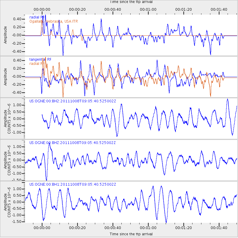
OGNE Ogallala, Nebraska, USA - Earthquake Result Viewer
*The percent match for this event was below the threshold and hence no stack was calculated.
| Earthquake location: |
Tonga Islands |
| Earthquake latitude/longitude: |
-20.6/-173.2 |
| Earthquake time(UTC): |
2011/10/08 (281) 08:53:11 GMT |
| Earthquake Depth: |
6.0 km |
| Earthquake Magnitude: |
6.1 MB, 5.6 MS, 5.9 MW, 5.9 MW |
| Earthquake Catalog/Contributor: |
WHDF/NEIC |
|
| Network: |
US United States National Seismic Network |
| Station: |
OGNE Ogallala, Nebraska, USA |
| Lat/Lon: |
40.95 N/102.03 W |
| Elevation: |
0.0 m |
|
| Distance: |
90.0 deg |
| Az: |
45.812 deg |
| Baz: |
242.472 deg |
| Ray Param: |
$rayparam |
*The percent match for this event was below the threshold and hence was not used in the summary stack. |
|
| Radial Match: |
65.844826 % |
| Radial Bump: |
400 |
| Transverse Match: |
49.659355 % |
| Transverse Bump: |
400 |
| SOD ConfigId: |
558545 |
| Insert Time: |
2013-09-19 04:05:52.439 +0000 |
| GWidth: |
2.5 |
| Max Bumps: |
400 |
| Tol: |
0.001 |
|
Signal To Noise
| Channel | StoN | STA | LTA |
| US:OGNE:00:BHZ:20111008T09:05:40.525002Z | 3.5288742 | 7.9661066E-7 | 2.2574075E-7 |
| US:OGNE:00:BH1:20111008T09:05:40.525002Z | 1.5913055 | 8.544575E-7 | 5.369538E-7 |
| US:OGNE:00:BH2:20111008T09:05:40.525002Z | 0.53248465 | 1.9271555E-7 | 3.6191756E-7 |
| Arrivals |
| Ps | |
| PpPs | |
| PsPs/PpSs | |


