You are here: Home > Network List > US - United States National Seismic Network Stations List
> Station ACSO Alum Creek State Park, Ohio, USA > Earthquake Result Viewer
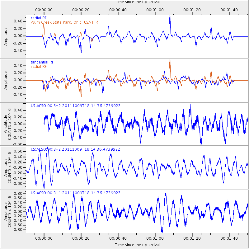
ACSO Alum Creek State Park, Ohio, USA - Earthquake Result Viewer
*The percent match for this event was below the threshold and hence no stack was calculated.
| Earthquake location: |
Southern East Pacific Rise |
| Earthquake latitude/longitude: |
-50.1/-116.0 |
| Earthquake time(UTC): |
2011/10/09 (282) 18:01:47 GMT |
| Earthquake Depth: |
10 km |
| Earthquake Magnitude: |
5.5 MW |
| Earthquake Catalog/Contributor: |
NEIC PDE/NEIC PDE-M |
|
| Network: |
US United States National Seismic Network |
| Station: |
ACSO Alum Creek State Park, Ohio, USA |
| Lat/Lon: |
40.23 N/82.98 W |
| Elevation: |
288 m |
|
| Distance: |
94.5 deg |
| Az: |
24.707 deg |
| Baz: |
200.595 deg |
| Ray Param: |
$rayparam |
*The percent match for this event was below the threshold and hence was not used in the summary stack. |
|
| Radial Match: |
57.027225 % |
| Radial Bump: |
400 |
| Transverse Match: |
58.813885 % |
| Transverse Bump: |
400 |
| SOD ConfigId: |
558545 |
| Insert Time: |
2013-09-19 04:08:18.572 +0000 |
| GWidth: |
2.5 |
| Max Bumps: |
400 |
| Tol: |
0.001 |
|
Signal To Noise
| Channel | StoN | STA | LTA |
| US:ACSO:00:BHZ:20111009T18:14:36.473992Z | 3.550636 | 5.144683E-7 | 1.4489468E-7 |
| US:ACSO:00:BH1:20111009T18:14:36.473992Z | 1.2999889 | 2.8613417E-7 | 2.2010511E-7 |
| US:ACSO:00:BH2:20111009T18:14:36.473992Z | 0.9215101 | 1.8016578E-7 | 1.9551146E-7 |
| Arrivals |
| Ps | |
| PpPs | |
| PsPs/PpSs | |


