You are here: Home > Network List > CN - Canadian National Seismograph Network Stations List
> Station INK INUVIK, NT, CANADA.ANADA > Earthquake Result Viewer
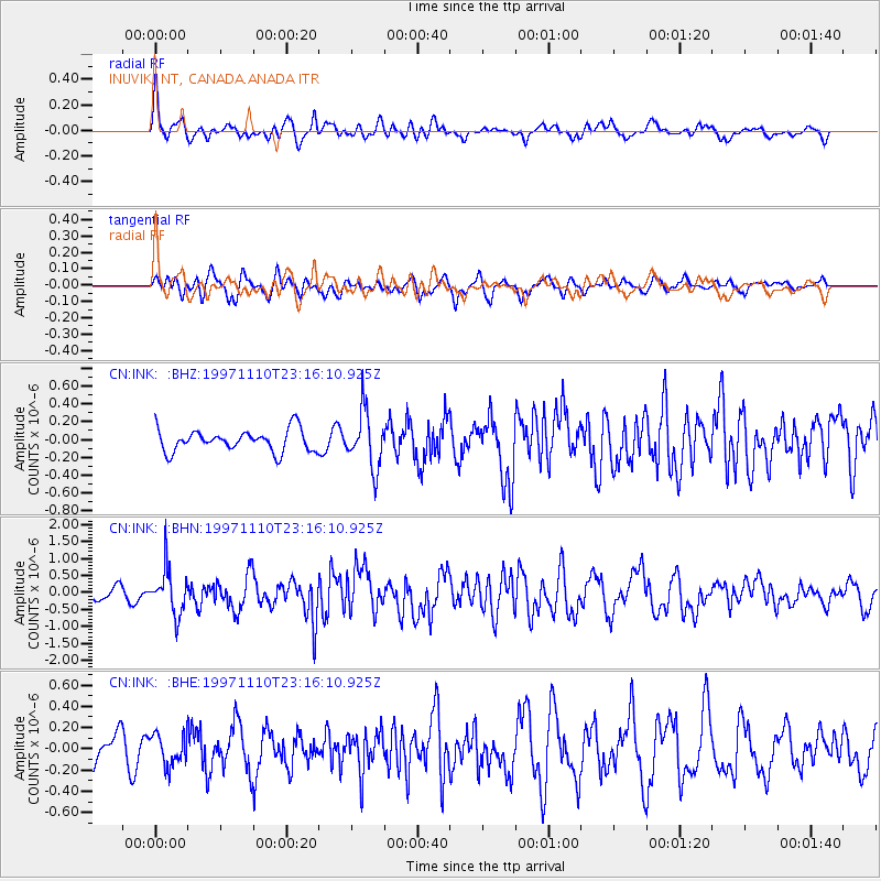
INK INUVIK, NT, CANADA.ANADA - Earthquake Result Viewer
*The percent match for this event was below the threshold and hence no stack was calculated.
| Earthquake location: |
Southeast Of Honshu, Japan |
| Earthquake latitude/longitude: |
31.2/140.5 |
| Earthquake time(UTC): |
1997/11/10 (314) 23:06:44 GMT |
| Earthquake Depth: |
86 km |
| Earthquake Magnitude: |
5.8 MB, 6.1 UNKNOWN, 6.1 MW |
| Earthquake Catalog/Contributor: |
WHDF/NEIC |
|
| Network: |
CN Canadian National Seismograph Network |
| Station: |
INK INUVIK, NT, CANADA.ANADA |
| Lat/Lon: |
68.31 N/133.52 W |
| Elevation: |
40 m |
|
| Distance: |
60.0 deg |
| Az: |
25.368 deg |
| Baz: |
279.039 deg |
| Ray Param: |
$rayparam |
*The percent match for this event was below the threshold and hence was not used in the summary stack. |
|
| Radial Match: |
75.931915 % |
| Radial Bump: |
400 |
| Transverse Match: |
63.62033 % |
| Transverse Bump: |
400 |
| SOD ConfigId: |
4480 |
| Insert Time: |
2010-02-27 06:28:44.327 +0000 |
| GWidth: |
2.5 |
| Max Bumps: |
400 |
| Tol: |
0.001 |
|
Signal To Noise
| Channel | StoN | STA | LTA |
| CN:INK: :BHN:19971110T23:16:10.925Z | 4.1815033 | 6.626928E-7 | 1.5848195E-7 |
| CN:INK: :BHE:19971110T23:16:10.925Z | 0.9436527 | 1.4490597E-7 | 1.5355857E-7 |
| CN:INK: :BHZ:19971110T23:16:10.925Z | 2.5941725 | 3.1661335E-7 | 1.2204792E-7 |
| Arrivals |
| Ps | |
| PpPs | |
| PsPs/PpSs | |


