You are here: Home > Network List > IU - Global Seismograph Network (GSN - IRIS/USGS) Stations List
> Station MAKZ Makanchi, Kazakhstan > Earthquake Result Viewer
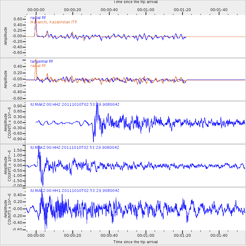
MAKZ Makanchi, Kazakhstan - Earthquake Result Viewer
*The percent match for this event was below the threshold and hence no stack was calculated.
| Earthquake location: |
Near East Coast Of Honshu, Japan |
| Earthquake latitude/longitude: |
37.5/141.3 |
| Earthquake time(UTC): |
2011/10/10 (283) 02:45:57 GMT |
| Earthquake Depth: |
46 km |
| Earthquake Magnitude: |
5.6 MW, 5.7 MW |
| Earthquake Catalog/Contributor: |
NEIC PDE/NEIC PDE-M |
|
| Network: |
IU Global Seismograph Network (GSN - IRIS/USGS) |
| Station: |
MAKZ Makanchi, Kazakhstan |
| Lat/Lon: |
46.81 N/81.98 E |
| Elevation: |
600 m |
|
| Distance: |
44.0 deg |
| Az: |
301.701 deg |
| Baz: |
79.898 deg |
| Ray Param: |
$rayparam |
*The percent match for this event was below the threshold and hence was not used in the summary stack. |
|
| Radial Match: |
76.69998 % |
| Radial Bump: |
400 |
| Transverse Match: |
55.87893 % |
| Transverse Bump: |
400 |
| SOD ConfigId: |
558545 |
| Insert Time: |
2013-09-19 04:10:12.792 +0000 |
| GWidth: |
2.5 |
| Max Bumps: |
400 |
| Tol: |
0.001 |
|
Signal To Noise
| Channel | StoN | STA | LTA |
| IU:MAKZ:00:HHZ:20111010T02:53:29.908004Z | 16.383795 | 9.280872E-7 | 5.6646662E-8 |
| IU:MAKZ:00:HH1:20111010T02:53:29.908004Z | 3.2908077 | 1.8171512E-7 | 5.5219004E-8 |
| IU:MAKZ:00:HH2:20111010T02:53:29.908004Z | 8.121576 | 4.9287684E-7 | 6.0687334E-8 |
| Arrivals |
| Ps | |
| PpPs | |
| PsPs/PpSs | |


