You are here: Home > Network List > US - United States National Seismic Network Stations List
> Station ACSO Alum Creek State Park, Ohio, USA > Earthquake Result Viewer
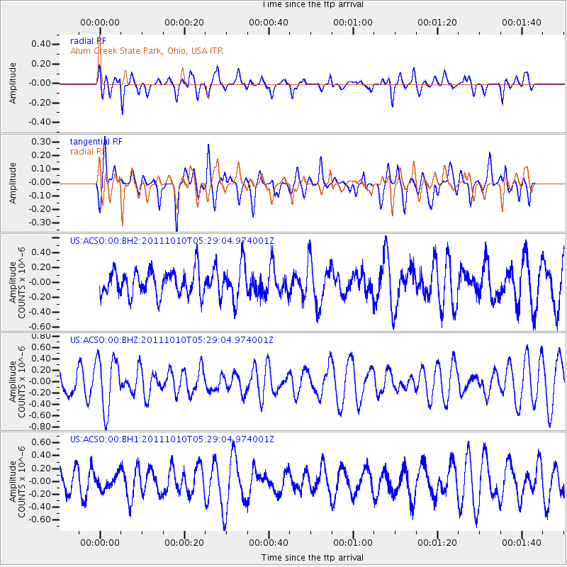
ACSO Alum Creek State Park, Ohio, USA - Earthquake Result Viewer
*The percent match for this event was below the threshold and hence no stack was calculated.
| Earthquake location: |
Southern East Pacific Rise |
| Earthquake latitude/longitude: |
-25.5/-116.2 |
| Earthquake time(UTC): |
2011/10/10 (283) 05:18:10 GMT |
| Earthquake Depth: |
10 km |
| Earthquake Magnitude: |
5.5 MW, 5.5 MB |
| Earthquake Catalog/Contributor: |
NEIC PDE/NEIC PDE-M |
|
| Network: |
US United States National Seismic Network |
| Station: |
ACSO Alum Creek State Park, Ohio, USA |
| Lat/Lon: |
40.23 N/82.98 W |
| Elevation: |
288 m |
|
| Distance: |
72.3 deg |
| Az: |
26.131 deg |
| Baz: |
211.337 deg |
| Ray Param: |
$rayparam |
*The percent match for this event was below the threshold and hence was not used in the summary stack. |
|
| Radial Match: |
52.265152 % |
| Radial Bump: |
400 |
| Transverse Match: |
67.48116 % |
| Transverse Bump: |
400 |
| SOD ConfigId: |
558545 |
| Insert Time: |
2013-09-19 04:12:54.115 +0000 |
| GWidth: |
2.5 |
| Max Bumps: |
400 |
| Tol: |
0.001 |
|
Signal To Noise
| Channel | StoN | STA | LTA |
| US:ACSO:00:BHZ:20111010T05:29:04.974001Z | 3.0478265 | 4.6590608E-7 | 1.5286503E-7 |
| US:ACSO:00:BH1:20111010T05:29:04.974001Z | 0.6047444 | 1.1446974E-7 | 1.8928617E-7 |
| US:ACSO:00:BH2:20111010T05:29:04.974001Z | 1.4884293 | 2.4973997E-7 | 1.6778758E-7 |
| Arrivals |
| Ps | |
| PpPs | |
| PsPs/PpSs | |


