You are here: Home > Network List > IU - Global Seismograph Network (GSN - IRIS/USGS) Stations List
> Station HNR Honiara, Solomon Islands > Earthquake Result Viewer
HNR Honiara, Solomon Islands - Earthquake Result Viewer
| Earthquake location: |
South Of Bali, Indonesia |
| Earthquake latitude/longitude: |
-9.4/114.6 |
| Earthquake time(UTC): |
2011/10/13 (286) 03:16:30 GMT |
| Earthquake Depth: |
39 km |
| Earthquake Magnitude: |
6.1 MB, 6.0 MS, 6.2 MW, 6.1 MW |
| Earthquake Catalog/Contributor: |
WHDF/NEIC |
|
| Network: |
IU Global Seismograph Network (GSN - IRIS/USGS) |
| Station: |
HNR Honiara, Solomon Islands |
| Lat/Lon: |
9.44 S/159.95 E |
| Elevation: |
100 m |
|
| Distance: |
44.7 deg |
| Az: |
93.984 deg |
| Baz: |
266.23 deg |
| Ray Param: |
0.07165301 |
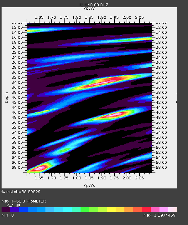
| Estimated Moho Depth: |
68.0 km |
| Estimated Crust Vp/Vs: |
1.65 |
| Assumed Crust Vp: |
6.183 km/s |
| Estimated Crust Vs: |
3.747 km/s |
| Estimated Crust Poisson's Ratio: |
0.21 |
|
| Radial Match: |
88.80829 % |
| Radial Bump: |
400 |
| Transverse Match: |
88.21972 % |
| Transverse Bump: |
400 |
| SOD ConfigId: |
558545 |
| Insert Time: |
2013-09-19 04:15:51.884 +0000 |
| GWidth: |
2.5 |
| Max Bumps: |
400 |
| Tol: |
0.001 |
|
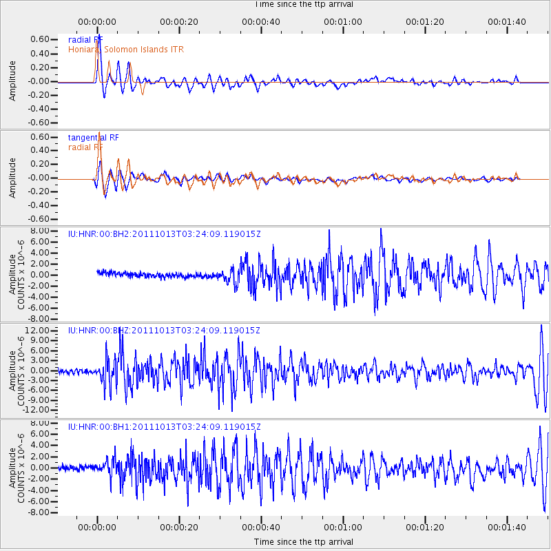
Signal To Noise
| Channel | StoN | STA | LTA |
| IU:HNR:00:BHZ:20111013T03:24:09.119015Z | 8.362153 | 3.7630234E-6 | 4.5000655E-7 |
| IU:HNR:00:BH1:20111013T03:24:09.119015Z | 3.2826958 | 1.4751091E-6 | 4.4935908E-7 |
| IU:HNR:00:BH2:20111013T03:24:09.119015Z | 3.324561 | 1.2288457E-6 | 3.6962643E-7 |
| Arrivals |
| Ps | 7.6 SECOND |
| PpPs | 27 SECOND |
| PsPs/PpSs | 35 SECOND |


