You are here: Home > Network List > IU - Global Seismograph Network (GSN - IRIS/USGS) Stations List
> Station HNR Honiara, Solomon Islands > Earthquake Result Viewer
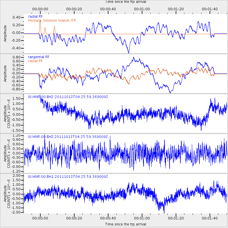
HNR Honiara, Solomon Islands - Earthquake Result Viewer
*The percent match for this event was below the threshold and hence no stack was calculated.
| Earthquake location: |
Off Coast Of Oregon |
| Earthquake latitude/longitude: |
43.5/-127.1 |
| Earthquake time(UTC): |
2011/10/13 (286) 04:14:00 GMT |
| Earthquake Depth: |
21 km |
| Earthquake Magnitude: |
5.6 MW, 5.0 MS, 5.4 MB |
| Earthquake Catalog/Contributor: |
WHDF/NEIC |
|
| Network: |
IU Global Seismograph Network (GSN - IRIS/USGS) |
| Station: |
HNR Honiara, Solomon Islands |
| Lat/Lon: |
9.44 S/159.95 E |
| Elevation: |
100 m |
|
| Distance: |
84.3 deg |
| Az: |
251.406 deg |
| Baz: |
44.385 deg |
| Ray Param: |
$rayparam |
*The percent match for this event was below the threshold and hence was not used in the summary stack. |
|
| Radial Match: |
28.382185 % |
| Radial Bump: |
400 |
| Transverse Match: |
44.71351 % |
| Transverse Bump: |
400 |
| SOD ConfigId: |
558545 |
| Insert Time: |
2013-09-19 04:17:11.691 +0000 |
| GWidth: |
2.5 |
| Max Bumps: |
400 |
| Tol: |
0.001 |
|
Signal To Noise
| Channel | StoN | STA | LTA |
| IU:HNR:00:BHZ:20111013T04:25:59.369009Z | 1.0901233 | 3.6558447E-7 | 3.3536068E-7 |
| IU:HNR:00:BH1:20111013T04:25:59.369009Z | 1.6755654 | 5.96843E-7 | 3.5620397E-7 |
| IU:HNR:00:BH2:20111013T04:25:59.369009Z | 2.4377425 | 1.0582835E-6 | 4.341244E-7 |
| Arrivals |
| Ps | |
| PpPs | |
| PsPs/PpSs | |


