You are here: Home > Network List > CN - Canadian National Seismograph Network Stations List
> Station INK INUVIK, NT, CANADA.ANADA > Earthquake Result Viewer
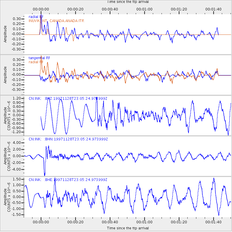
INK INUVIK, NT, CANADA.ANADA - Earthquake Result Viewer
*The percent match for this event was below the threshold and hence no stack was calculated.
| Earthquake location: |
Peru-Bolivia Border Region |
| Earthquake latitude/longitude: |
-13.7/-68.8 |
| Earthquake time(UTC): |
1997/11/28 (332) 22:53:41 GMT |
| Earthquake Depth: |
586 km |
| Earthquake Magnitude: |
6.4 MB, 6.6 UNKNOWN, 6.6 MW |
| Earthquake Catalog/Contributor: |
WHDF/NEIC |
|
| Network: |
CN Canadian National Seismograph Network |
| Station: |
INK INUVIK, NT, CANADA.ANADA |
| Lat/Lon: |
68.31 N/133.52 W |
| Elevation: |
40 m |
|
| Distance: |
93.7 deg |
| Az: |
340.31 deg |
| Baz: |
118.282 deg |
| Ray Param: |
$rayparam |
*The percent match for this event was below the threshold and hence was not used in the summary stack. |
|
| Radial Match: |
57.769024 % |
| Radial Bump: |
400 |
| Transverse Match: |
46.71019 % |
| Transverse Bump: |
337 |
| SOD ConfigId: |
4480 |
| Insert Time: |
2010-02-27 06:29:02.298 +0000 |
| GWidth: |
2.5 |
| Max Bumps: |
400 |
| Tol: |
0.001 |
|
Signal To Noise
| Channel | StoN | STA | LTA |
| CN:INK: :BHN:19971128T23:05:24.973999Z | 6.149785 | 2.3105542E-6 | 3.7571303E-7 |
| CN:INK: :BHE:19971128T23:05:24.973999Z | 0.58725476 | 3.2420576E-7 | 5.5207E-7 |
| CN:INK: :BHZ:19971128T23:05:24.973999Z | 0.69640213 | 5.46599E-7 | 7.8488983E-7 |
| Arrivals |
| Ps | |
| PpPs | |
| PsPs/PpSs | |


