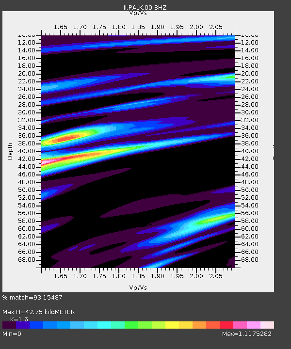
PALK Pallekele, Sri Lanka - Earthquake Result Viewer
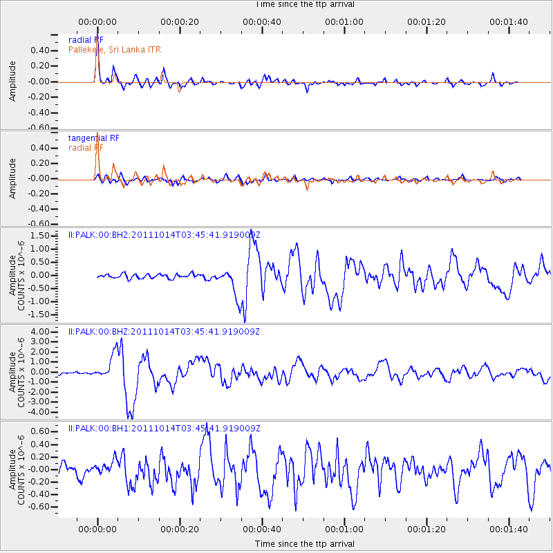
Earthquake location: Eastern New Guinea Reg., P.N.G.
Earthquake latitude/longitude: -6.6/147.9
Earthquake time(UTC): 2011/10/14 (287) 03:35:14 GMT
Earthquake Depth: 37 km
Earthquake Magnitude: 5.7 MB, 6.5 MS, 6.5 MW, 6.5 MW
Earthquake Catalog/Contributor: WHDF/NEIC
Network: II Global Seismograph Network (GSN - IRIS/IDA)
Station: PALK Pallekele, Sri Lanka
Lat/Lon: 7.27 N/80.70 E
Elevation: 460 m
Distance: 68.4 deg
Az: 280.452 deg
Baz: 99.985 deg
Ray Param: 0.056261808
Estimated Moho Depth: 42.75 km
Estimated Crust Vp/Vs: 1.60
Assumed Crust Vp: 6.545 km/s
Estimated Crust Vs: 4.091 km/s
Estimated Crust Poisson's Ratio: 0.18
Radial Match: 93.15487 %
Radial Bump: 400
Transverse Match: 83.0125 %
Transverse Bump: 400
SOD ConfigId: 558545
Insert Time: 2013-09-19 04:20:47.390 +0000
GWidth: 2.5
Max Bumps: 400
Tol: 0.001

Signal To Noise

ChannelStoNSTALTA
II:PALK:00:BHZ:20111014T03:45:41.919009Z9.7671871.3195056E-61.3509576E-7
II:PALK:00:BH1:20111014T03:45:41.919009Z1.00722731.1559052E-71.147611E-7
II:PALK:00:BH2:20111014T03:45:41.919009Z7.3656125.8323434E-77.9183415E-8
Arrivals
Ps4.1 SECOND
PpPs16 SECOND
PsPs/PpSs20 SECOND