You are here: Home > Network List > IU - Global Seismograph Network (GSN - IRIS/USGS) Stations List
> Station JOHN Johnston Island, USA > Earthquake Result Viewer
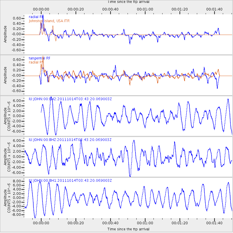
JOHN Johnston Island, USA - Earthquake Result Viewer
*The percent match for this event was below the threshold and hence no stack was calculated.
| Earthquake location: |
Eastern New Guinea Reg., P.N.G. |
| Earthquake latitude/longitude: |
-6.6/147.9 |
| Earthquake time(UTC): |
2011/10/14 (287) 03:35:14 GMT |
| Earthquake Depth: |
37 km |
| Earthquake Magnitude: |
5.7 MB, 6.5 MS, 6.5 MW, 6.5 MW |
| Earthquake Catalog/Contributor: |
WHDF/NEIC |
|
| Network: |
IU Global Seismograph Network (GSN - IRIS/USGS) |
| Station: |
JOHN Johnston Island, USA |
| Lat/Lon: |
16.73 N/169.53 W |
| Elevation: |
2.0 m |
|
| Distance: |
48.1 deg |
| Az: |
60.661 deg |
| Baz: |
244.673 deg |
| Ray Param: |
$rayparam |
*The percent match for this event was below the threshold and hence was not used in the summary stack. |
|
| Radial Match: |
56.578957 % |
| Radial Bump: |
368 |
| Transverse Match: |
65.60548 % |
| Transverse Bump: |
347 |
| SOD ConfigId: |
558545 |
| Insert Time: |
2013-09-19 04:21:07.162 +0000 |
| GWidth: |
2.5 |
| Max Bumps: |
400 |
| Tol: |
0.001 |
|
Signal To Noise
| Channel | StoN | STA | LTA |
| IU:JOHN:00:BHZ:20111014T03:43:20.069003Z | 1.8405519 | 3.6652127E-6 | 1.9913662E-6 |
| IU:JOHN:00:BH1:20111014T03:43:20.069003Z | 1.7465429 | 5.9030735E-6 | 3.3798617E-6 |
| IU:JOHN:00:BH2:20111014T03:43:20.069003Z | 0.8143124 | 3.1475272E-6 | 3.8652574E-6 |
| Arrivals |
| Ps | |
| PpPs | |
| PsPs/PpSs | |


