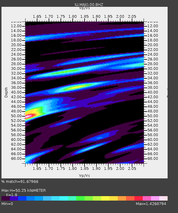
MAJO Matsushiro, Japan - Earthquake Result Viewer

Earthquake location: Eastern New Guinea Reg., P.N.G.
Earthquake latitude/longitude: -6.6/147.9
Earthquake time(UTC): 2011/10/14 (287) 03:35:14 GMT
Earthquake Depth: 37 km
Earthquake Magnitude: 5.7 MB, 6.5 MS, 6.5 MW, 6.5 MW
Earthquake Catalog/Contributor: WHDF/NEIC
Network: IU Global Seismograph Network (GSN - IRIS/USGS)
Station: MAJO Matsushiro, Japan
Lat/Lon: 36.55 N/138.20 E
Elevation: 405 m
Distance: 43.8 deg
Az: 348.73 deg
Baz: 166.048 deg
Ray Param: 0.07220873
Estimated Moho Depth: 50.25 km
Estimated Crust Vp/Vs: 1.60
Assumed Crust Vp: 6.461 km/s
Estimated Crust Vs: 4.038 km/s
Estimated Crust Poisson's Ratio: 0.18
Radial Match: 91.67966 %
Radial Bump: 392
Transverse Match: 89.420746 %
Transverse Bump: 400
SOD ConfigId: 558545
Insert Time: 2013-09-19 04:21:08.335 +0000
GWidth: 2.5
Max Bumps: 400
Tol: 0.001

Signal To Noise

ChannelStoNSTALTA
IU:MAJO:00:BHZ:20111014T03:42:46.86899Z67.9510353.9588426E-65.8260223E-8
IU:MAJO:00:BH1:20111014T03:42:46.86899Z35.171712.3550479E-66.695858E-8
IU:MAJO:00:BH2:20111014T03:42:46.86899Z11.4248635.8591326E-75.1284047E-8
Arrivals
Ps5.0 SECOND
PpPs19 SECOND
PsPs/PpSs24 SECOND