You are here: Home > Network List > US - United States National Seismic Network Stations List
> Station WRAK Wrangell Island, Southeastern Alaska, Alaska, USA > Earthquake Result Viewer
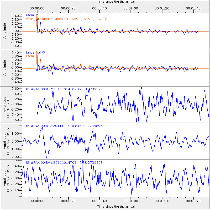
WRAK Wrangell Island, Southeastern Alaska, Alaska, USA - Earthquake Result Viewer
*The percent match for this event was below the threshold and hence no stack was calculated.
| Earthquake location: |
Eastern New Guinea Reg., P.N.G. |
| Earthquake latitude/longitude: |
-6.6/147.9 |
| Earthquake time(UTC): |
2011/10/14 (287) 03:35:14 GMT |
| Earthquake Depth: |
37 km |
| Earthquake Magnitude: |
5.7 MB, 6.5 MS, 6.5 MW, 6.5 MW |
| Earthquake Catalog/Contributor: |
WHDF/NEIC |
|
| Network: |
US United States National Seismic Network |
| Station: |
WRAK Wrangell Island, Southeastern Alaska, Alaska, USA |
| Lat/Lon: |
56.42 N/132.35 W |
| Elevation: |
81 m |
|
| Distance: |
89.8 deg |
| Az: |
33.152 deg |
| Baz: |
257.888 deg |
| Ray Param: |
$rayparam |
*The percent match for this event was below the threshold and hence was not used in the summary stack. |
|
| Radial Match: |
67.91399 % |
| Radial Bump: |
400 |
| Transverse Match: |
54.711506 % |
| Transverse Bump: |
400 |
| SOD ConfigId: |
558545 |
| Insert Time: |
2013-09-19 04:21:57.918 +0000 |
| GWidth: |
2.5 |
| Max Bumps: |
400 |
| Tol: |
0.001 |
|
Signal To Noise
| Channel | StoN | STA | LTA |
| US:WRAK:00:BHZ:20111014T03:47:38.273989Z | 3.6380537 | 9.935738E-7 | 2.7310588E-7 |
| US:WRAK:00:BH1:20111014T03:47:38.273989Z | 1.0852998 | 1.9257136E-7 | 1.7743609E-7 |
| US:WRAK:00:BH2:20111014T03:47:38.273989Z | 1.7494802 | 3.9148665E-7 | 2.2377311E-7 |
| Arrivals |
| Ps | |
| PpPs | |
| PsPs/PpSs | |


