You are here: Home > Network List > CN - Canadian National Seismograph Network Stations List
> Station INK INUVIK, NT, CANADA.ANADA > Earthquake Result Viewer
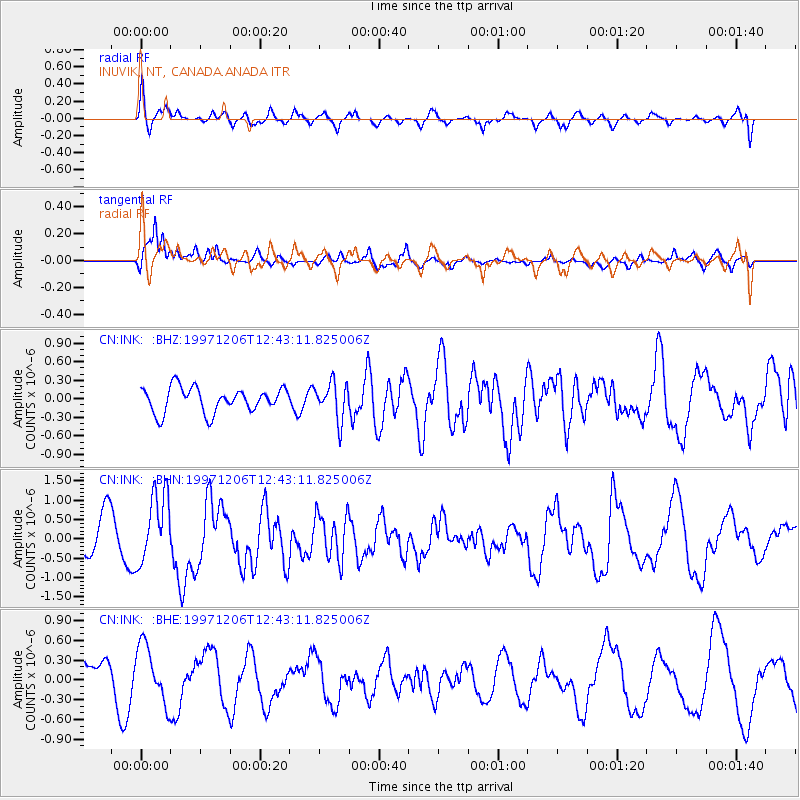
INK INUVIK, NT, CANADA.ANADA - Earthquake Result Viewer
*The percent match for this event was below the threshold and hence no stack was calculated.
| Earthquake location: |
Near East Coast Of Kamchatka |
| Earthquake latitude/longitude: |
54.9/162.1 |
| Earthquake time(UTC): |
1997/12/06 (340) 12:37:21 GMT |
| Earthquake Depth: |
33 km |
| Earthquake Magnitude: |
5.5 MB, 5.6 MS, 5.9 UNKNOWN, 5.8 MW |
| Earthquake Catalog/Contributor: |
WHDF/NEIC |
|
| Network: |
CN Canadian National Seismograph Network |
| Station: |
INK INUVIK, NT, CANADA.ANADA |
| Lat/Lon: |
68.31 N/133.52 W |
| Elevation: |
40 m |
|
| Distance: |
31.7 deg |
| Az: |
39.644 deg |
| Baz: |
277.859 deg |
| Ray Param: |
$rayparam |
*The percent match for this event was below the threshold and hence was not used in the summary stack. |
|
| Radial Match: |
57.240337 % |
| Radial Bump: |
400 |
| Transverse Match: |
68.451485 % |
| Transverse Bump: |
400 |
| SOD ConfigId: |
4480 |
| Insert Time: |
2010-02-27 06:29:21.113 +0000 |
| GWidth: |
2.5 |
| Max Bumps: |
400 |
| Tol: |
0.001 |
|
Signal To Noise
| Channel | StoN | STA | LTA |
| CN:INK: :BHN:19971206T12:43:11.825006Z | 2.5705914 | 9.1566204E-7 | 3.5620675E-7 |
| CN:INK: :BHE:19971206T12:43:11.825006Z | 1.5576513 | 4.374582E-7 | 2.8084474E-7 |
| CN:INK: :BHZ:19971206T12:43:11.825006Z | 1.5037564 | 2.9948032E-7 | 1.991548E-7 |
| Arrivals |
| Ps | |
| PpPs | |
| PsPs/PpSs | |


