You are here: Home > Network List > US - United States National Seismic Network Stations List
> Station TPNV Topopah Spring, Nevada, USA > Earthquake Result Viewer
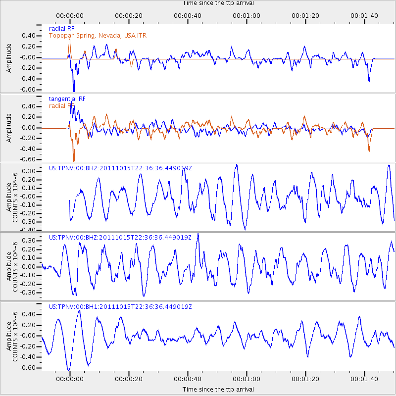
TPNV Topopah Spring, Nevada, USA - Earthquake Result Viewer
*The percent match for this event was below the threshold and hence no stack was calculated.
| Earthquake location: |
South Of Fiji Islands |
| Earthquake latitude/longitude: |
-25.8/-177.5 |
| Earthquake time(UTC): |
2011/10/15 (288) 22:24:49 GMT |
| Earthquake Depth: |
148 km |
| Earthquake Magnitude: |
5.5 MW |
| Earthquake Catalog/Contributor: |
NEIC PDE/NEIC PDE-M |
|
| Network: |
US United States National Seismic Network |
| Station: |
TPNV Topopah Spring, Nevada, USA |
| Lat/Lon: |
36.95 N/116.25 W |
| Elevation: |
1600 m |
|
| Distance: |
84.9 deg |
| Az: |
44.817 deg |
| Baz: |
232.487 deg |
| Ray Param: |
$rayparam |
*The percent match for this event was below the threshold and hence was not used in the summary stack. |
|
| Radial Match: |
67.498604 % |
| Radial Bump: |
400 |
| Transverse Match: |
33.553337 % |
| Transverse Bump: |
400 |
| SOD ConfigId: |
558545 |
| Insert Time: |
2013-09-19 04:26:20.529 +0000 |
| GWidth: |
2.5 |
| Max Bumps: |
400 |
| Tol: |
0.001 |
|
Signal To Noise
| Channel | StoN | STA | LTA |
| US:TPNV:00:BHZ:20111015T22:36:36.449019Z | 2.102591 | 2.2117705E-7 | 1.0519261E-7 |
| US:TPNV:00:BH1:20111015T22:36:36.449019Z | 2.3231122 | 3.9522217E-7 | 1.7012616E-7 |
| US:TPNV:00:BH2:20111015T22:36:36.449019Z | 0.876509 | 1.2912268E-7 | 1.4731472E-7 |
| Arrivals |
| Ps | |
| PpPs | |
| PsPs/PpSs | |


