You are here: Home > Network List > IU - Global Seismograph Network (GSN - IRIS/USGS) Stations List
> Station HNR Honiara, Solomon Islands > Earthquake Result Viewer
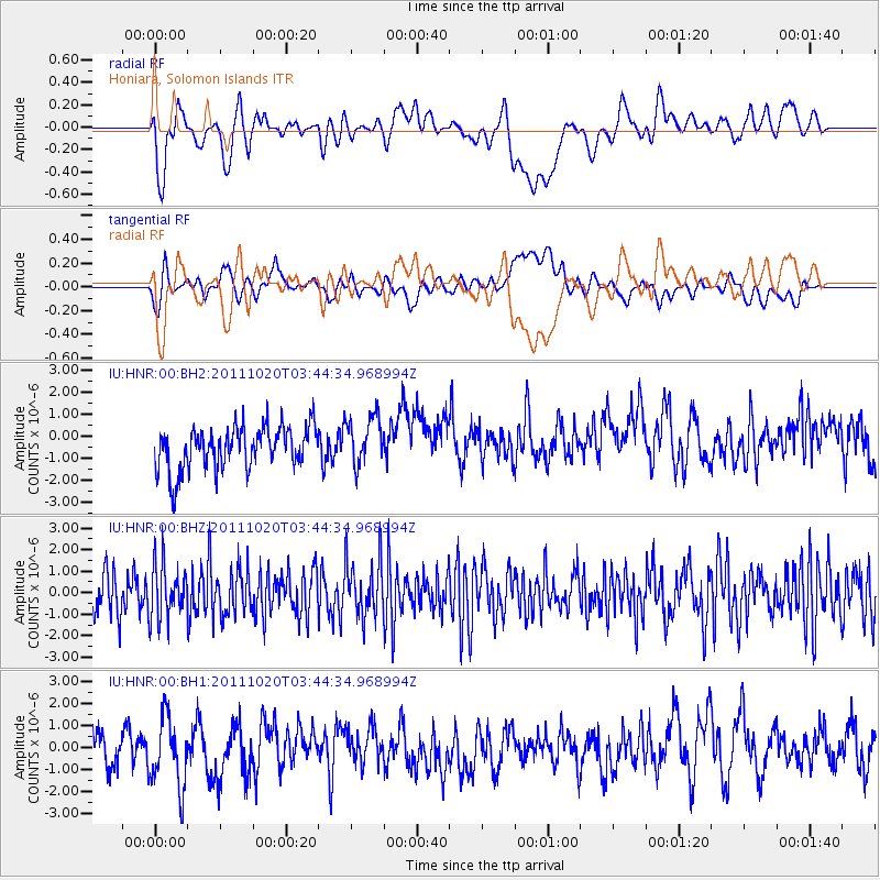
HNR Honiara, Solomon Islands - Earthquake Result Viewer
*The percent match for this event was below the threshold and hence no stack was calculated.
| Earthquake location: |
Kermadec Islands Region |
| Earthquake latitude/longitude: |
-29.8/-176.3 |
| Earthquake time(UTC): |
2011/10/20 (293) 03:39:00 GMT |
| Earthquake Depth: |
44 km |
| Earthquake Magnitude: |
5.5 MB |
| Earthquake Catalog/Contributor: |
NEIC PDE/NEIC PDE-M |
|
| Network: |
IU Global Seismograph Network (GSN - IRIS/USGS) |
| Station: |
HNR Honiara, Solomon Islands |
| Lat/Lon: |
9.44 S/159.95 E |
| Elevation: |
100 m |
|
| Distance: |
30.0 deg |
| Az: |
307.525 deg |
| Baz: |
135.679 deg |
| Ray Param: |
$rayparam |
*The percent match for this event was below the threshold and hence was not used in the summary stack. |
|
| Radial Match: |
48.047413 % |
| Radial Bump: |
400 |
| Transverse Match: |
51.410927 % |
| Transverse Bump: |
400 |
| SOD ConfigId: |
558545 |
| Insert Time: |
2013-09-19 04:31:52.923 +0000 |
| GWidth: |
2.5 |
| Max Bumps: |
400 |
| Tol: |
0.001 |
|
Signal To Noise
| Channel | StoN | STA | LTA |
| IU:HNR:00:BHZ:20111020T03:44:34.968994Z | 1.1022396 | 1.3114814E-6 | 1.1898334E-6 |
| IU:HNR:00:BH1:20111020T03:44:34.968994Z | 2.0442026 | 1.6354405E-6 | 8.000384E-7 |
| IU:HNR:00:BH2:20111020T03:44:34.968994Z | 1.1401696 | 1.1166056E-6 | 9.793329E-7 |
| Arrivals |
| Ps | |
| PpPs | |
| PsPs/PpSs | |


