You are here: Home > Network List > CN - Canadian National Seismograph Network Stations List
> Station INK INUVIK, NT, CANADA.ANADA > Earthquake Result Viewer
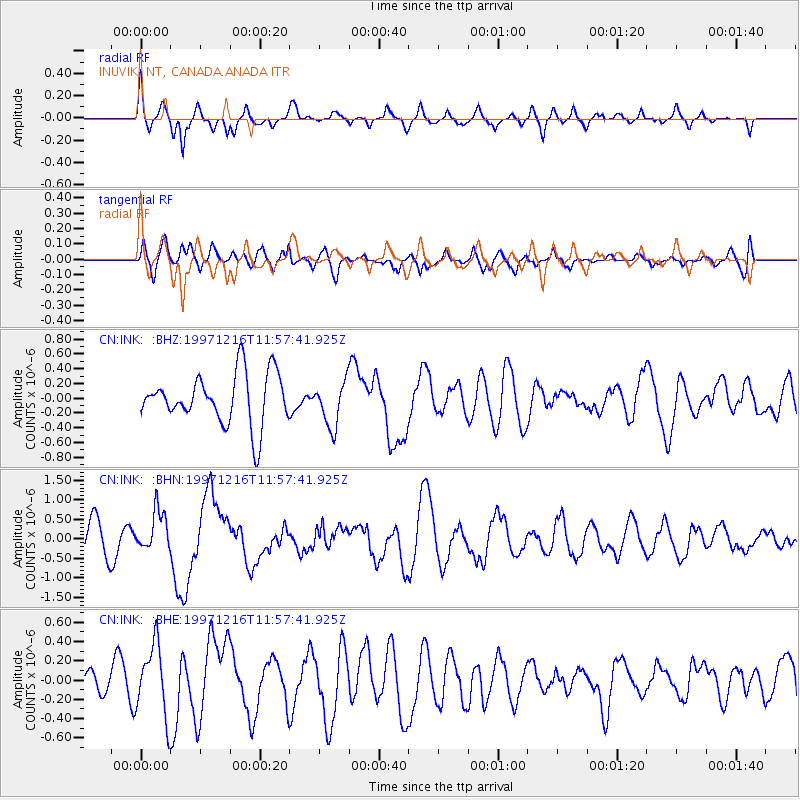
INK INUVIK, NT, CANADA.ANADA - Earthquake Result Viewer
*The percent match for this event was below the threshold and hence no stack was calculated.
| Earthquake location: |
Near Coast Of Guerrero, Mexico |
| Earthquake latitude/longitude: |
16.1/-98.9 |
| Earthquake time(UTC): |
1997/12/16 (350) 11:48:29 GMT |
| Earthquake Depth: |
10 km |
| Earthquake Magnitude: |
5.5 MB, 5.5 MS, 6.3 UNKNOWN, 6.2 MW |
| Earthquake Catalog/Contributor: |
WHDF/NEIC |
|
| Network: |
CN Canadian National Seismograph Network |
| Station: |
INK INUVIK, NT, CANADA.ANADA |
| Lat/Lon: |
68.31 N/133.52 W |
| Elevation: |
40 m |
|
| Distance: |
56.6 deg |
| Az: |
345.333 deg |
| Baz: |
139.109 deg |
| Ray Param: |
$rayparam |
*The percent match for this event was below the threshold and hence was not used in the summary stack. |
|
| Radial Match: |
63.308403 % |
| Radial Bump: |
400 |
| Transverse Match: |
44.99942 % |
| Transverse Bump: |
400 |
| SOD ConfigId: |
4480 |
| Insert Time: |
2010-02-27 06:29:32.105 +0000 |
| GWidth: |
2.5 |
| Max Bumps: |
400 |
| Tol: |
0.001 |
|
Signal To Noise
| Channel | StoN | STA | LTA |
| CN:INK: :BHN:19971216T11:57:41.925Z | 1.6833172 | 5.123657E-7 | 3.043786E-7 |
| CN:INK: :BHE:19971216T11:57:41.925Z | 1.6689063 | 3.6828195E-7 | 2.2067263E-7 |
| CN:INK: :BHZ:19971216T11:57:41.925Z | 0.8921692 | 3.061904E-7 | 3.4319768E-7 |
| Arrivals |
| Ps | |
| PpPs | |
| PsPs/PpSs | |


