You are here: Home > Network List > US - United States National Seismic Network Stations List
> Station ACSO Alum Creek State Park, Ohio, USA > Earthquake Result Viewer
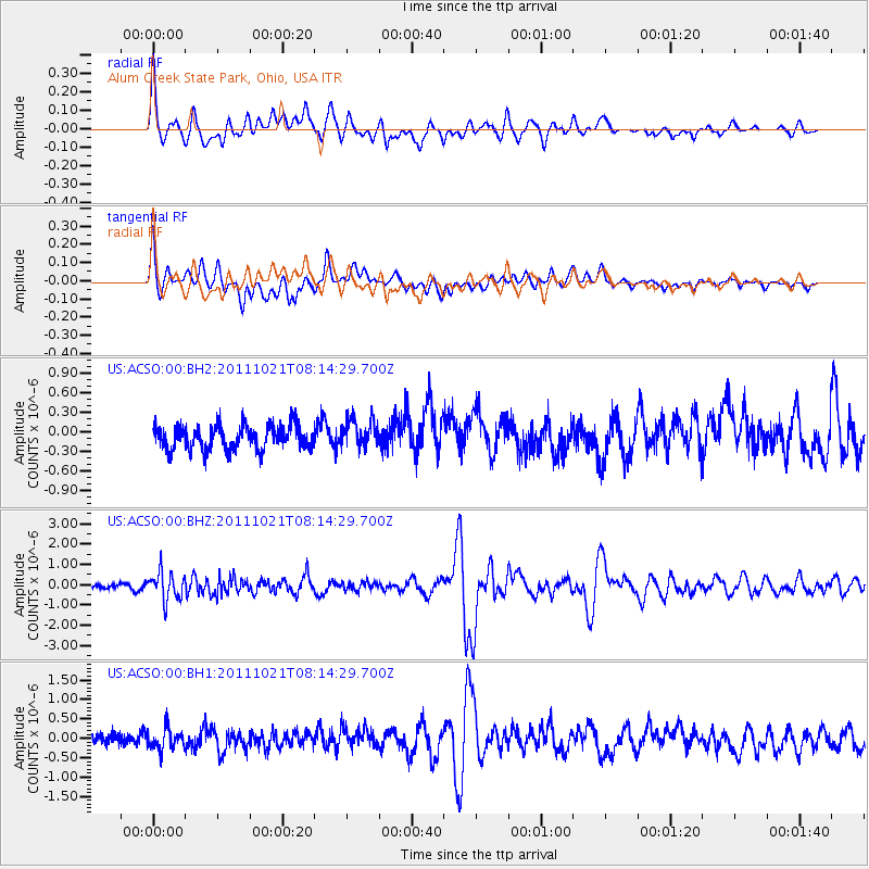
ACSO Alum Creek State Park, Ohio, USA - Earthquake Result Viewer
*The percent match for this event was below the threshold and hence no stack was calculated.
| Earthquake location: |
Hokkaido, Japan Region |
| Earthquake latitude/longitude: |
43.9/142.5 |
| Earthquake time(UTC): |
2011/10/21 (294) 08:02:37 GMT |
| Earthquake Depth: |
187 km |
| Earthquake Magnitude: |
5.9 MB, 6.1 MW, 6.1 MW |
| Earthquake Catalog/Contributor: |
WHDF/NEIC |
|
| Network: |
US United States National Seismic Network |
| Station: |
ACSO Alum Creek State Park, Ohio, USA |
| Lat/Lon: |
40.23 N/82.98 W |
| Elevation: |
288 m |
|
| Distance: |
86.8 deg |
| Az: |
33.13 deg |
| Baz: |
328.927 deg |
| Ray Param: |
$rayparam |
*The percent match for this event was below the threshold and hence was not used in the summary stack. |
|
| Radial Match: |
79.90925 % |
| Radial Bump: |
400 |
| Transverse Match: |
55.940563 % |
| Transverse Bump: |
400 |
| SOD ConfigId: |
558545 |
| Insert Time: |
2013-09-19 04:35:29.172 +0000 |
| GWidth: |
2.5 |
| Max Bumps: |
400 |
| Tol: |
0.001 |
|
Signal To Noise
| Channel | StoN | STA | LTA |
| US:ACSO:00:BHZ:20111021T08:14:29.700Z | 4.15565 | 6.858584E-7 | 1.6504238E-7 |
| US:ACSO:00:BH1:20111021T08:14:29.700Z | 1.3491477 | 2.7554432E-7 | 2.0423586E-7 |
| US:ACSO:00:BH2:20111021T08:14:29.700Z | 1.1753854 | 2.1750611E-7 | 1.850509E-7 |
| Arrivals |
| Ps | |
| PpPs | |
| PsPs/PpSs | |


