You are here: Home > Network List > US - United States National Seismic Network Stations List
> Station CBKS Cedar Bluff, Kansas, USA > Earthquake Result Viewer
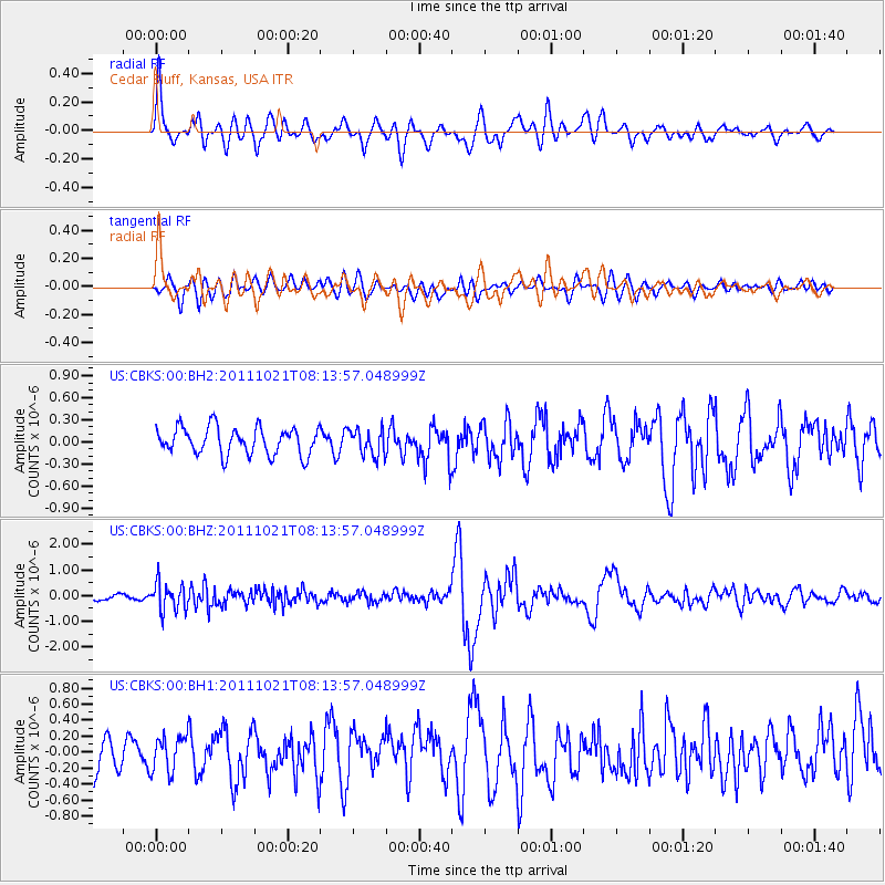
CBKS Cedar Bluff, Kansas, USA - Earthquake Result Viewer
*The percent match for this event was below the threshold and hence no stack was calculated.
| Earthquake location: |
Hokkaido, Japan Region |
| Earthquake latitude/longitude: |
43.9/142.5 |
| Earthquake time(UTC): |
2011/10/21 (294) 08:02:37 GMT |
| Earthquake Depth: |
187 km |
| Earthquake Magnitude: |
5.9 MB, 6.1 MW, 6.1 MW |
| Earthquake Catalog/Contributor: |
WHDF/NEIC |
|
| Network: |
US United States National Seismic Network |
| Station: |
CBKS Cedar Bluff, Kansas, USA |
| Lat/Lon: |
38.81 N/99.74 W |
| Elevation: |
677 m |
|
| Distance: |
80.3 deg |
| Az: |
44.518 deg |
| Baz: |
319.546 deg |
| Ray Param: |
$rayparam |
*The percent match for this event was below the threshold and hence was not used in the summary stack. |
|
| Radial Match: |
66.654335 % |
| Radial Bump: |
400 |
| Transverse Match: |
51.273956 % |
| Transverse Bump: |
400 |
| SOD ConfigId: |
558545 |
| Insert Time: |
2013-09-19 04:35:49.497 +0000 |
| GWidth: |
2.5 |
| Max Bumps: |
400 |
| Tol: |
0.001 |
|
Signal To Noise
| Channel | StoN | STA | LTA |
| US:CBKS:00:BHZ:20111021T08:13:57.048999Z | 4.2868533 | 5.5133404E-7 | 1.2861044E-7 |
| US:CBKS:00:BH1:20111021T08:13:57.048999Z | 1.1281915 | 2.2044007E-7 | 1.9539243E-7 |
| US:CBKS:00:BH2:20111021T08:13:57.048999Z | 0.9734494 | 1.7955824E-7 | 1.8445564E-7 |
| Arrivals |
| Ps | |
| PpPs | |
| PsPs/PpSs | |


