You are here: Home > Network List > CN - Canadian National Seismograph Network Stations List
> Station INK INUVIK, NT, CANADA.ANADA > Earthquake Result Viewer
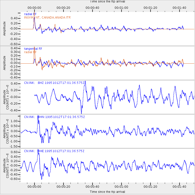
INK INUVIK, NT, CANADA.ANADA - Earthquake Result Viewer
*The percent match for this event was below the threshold and hence no stack was calculated.
| Earthquake location: |
Near Coast Of Jalisco, Mexico |
| Earthquake latitude/longitude: |
18.8/-104.0 |
| Earthquake time(UTC): |
1995/10/12 (285) 16:52:54 GMT |
| Earthquake Depth: |
25 km |
| Earthquake Magnitude: |
5.5 MB, 5.5 MS, 5.2 UNKNOWN, 6.0 MW |
| Earthquake Catalog/Contributor: |
WHDF/NEIC |
|
| Network: |
CN Canadian National Seismograph Network |
| Station: |
INK INUVIK, NT, CANADA.ANADA |
| Lat/Lon: |
68.31 N/133.52 W |
| Elevation: |
40 m |
|
| Distance: |
52.8 deg |
| Az: |
346.712 deg |
| Baz: |
144.161 deg |
| Ray Param: |
$rayparam |
*The percent match for this event was below the threshold and hence was not used in the summary stack. |
|
| Radial Match: |
67.28937 % |
| Radial Bump: |
386 |
| Transverse Match: |
47.61425 % |
| Transverse Bump: |
400 |
| SOD ConfigId: |
4480 |
| Insert Time: |
2010-02-27 06:29:40.125 +0000 |
| GWidth: |
2.5 |
| Max Bumps: |
400 |
| Tol: |
0.001 |
|
Signal To Noise
| Channel | StoN | STA | LTA |
| CN:INK: :BHN:19951012T17:01:36.575Z | 4.2489276 | 5.805057E-7 | 1.3662404E-7 |
| CN:INK: :BHE:19951012T17:01:36.575Z | 3.2476974 | 3.4880333E-7 | 1.074002E-7 |
| CN:INK: :BHZ:19951012T17:01:36.575Z | 2.1274414 | 2.1687622E-7 | 1.0194228E-7 |
| Arrivals |
| Ps | |
| PpPs | |
| PsPs/PpSs | |


