You are here: Home > Network List > CI - Caltech Regional Seismic Network Stations List
> Station LRL Laurel Mtn Radio Fac, Ridgecrest, CA, USA > Earthquake Result Viewer
LRL Laurel Mtn Radio Fac, Ridgecrest, CA, USA - Earthquake Result Viewer
| Earthquake location: |
Near S. Coast Of Western Honshu |
| Earthquake latitude/longitude: |
33.1/136.6 |
| Earthquake time(UTC): |
2004/09/05 (249) 10:07:07 GMT |
| Earthquake Depth: |
14 km |
| Earthquake Magnitude: |
6.7 MB, 7.0 MS, 7.2 MW, 7.0 MW |
| Earthquake Catalog/Contributor: |
WHDF/NEIC |
|
| Network: |
CI Caltech Regional Seismic Network |
| Station: |
LRL Laurel Mtn Radio Fac, Ridgecrest, CA, USA |
| Lat/Lon: |
35.48 N/117.68 W |
| Elevation: |
1340 m |
|
| Distance: |
82.6 deg |
| Az: |
52.398 deg |
| Baz: |
305.404 deg |
| Ray Param: |
0.04675064 |
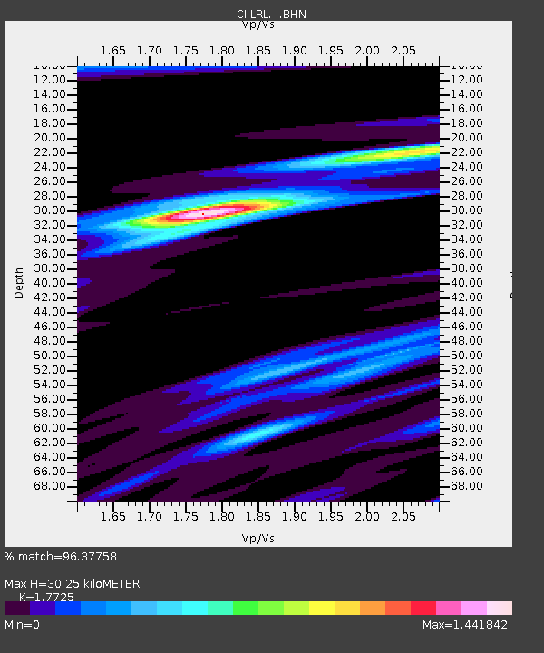
| Estimated Moho Depth: |
30.25 km |
| Estimated Crust Vp/Vs: |
1.77 |
| Assumed Crust Vp: |
6.276 km/s |
| Estimated Crust Vs: |
3.541 km/s |
| Estimated Crust Poisson's Ratio: |
0.27 |
|
| Radial Match: |
96.37758 % |
| Radial Bump: |
363 |
| Transverse Match: |
89.12888 % |
| Transverse Bump: |
400 |
| SOD ConfigId: |
2459 |
| Insert Time: |
2010-02-25 20:39:39.571 +0000 |
| GWidth: |
2.5 |
| Max Bumps: |
400 |
| Tol: |
0.001 |
|
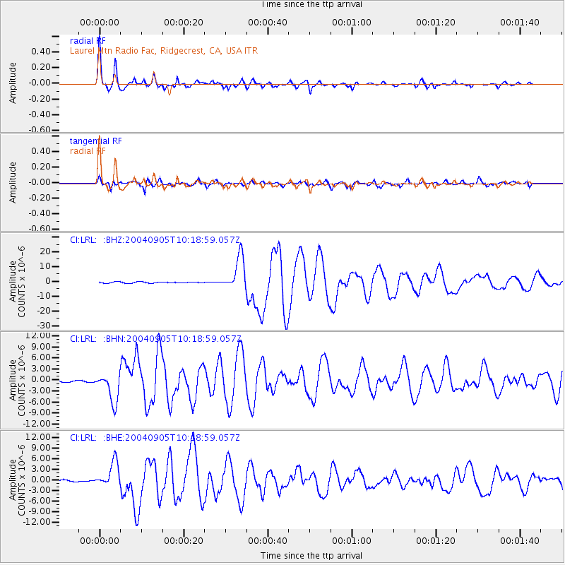
Signal To Noise
| Channel | StoN | STA | LTA |
| CI:LRL: :BHN:20040905T10:18:59.057Z | 7.033704 | 4.074065E-6 | 5.7922045E-7 |
| CI:LRL: :BHE:20040905T10:18:59.057Z | 14.910193 | 3.6997737E-6 | 2.481372E-7 |
| CI:LRL: :BHZ:20040905T10:18:59.057Z | 27.85401 | 1.173406E-5 | 4.2127004E-7 |
| Arrivals |
| Ps | 3.8 SECOND |
| PpPs | 13 SECOND |
| PsPs/PpSs | 17 SECOND |


