You are here: Home > Network List > US - United States National Seismic Network Stations List
> Station WRAK Wrangell Island, Southeastern Alaska, Alaska, USA > Earthquake Result Viewer
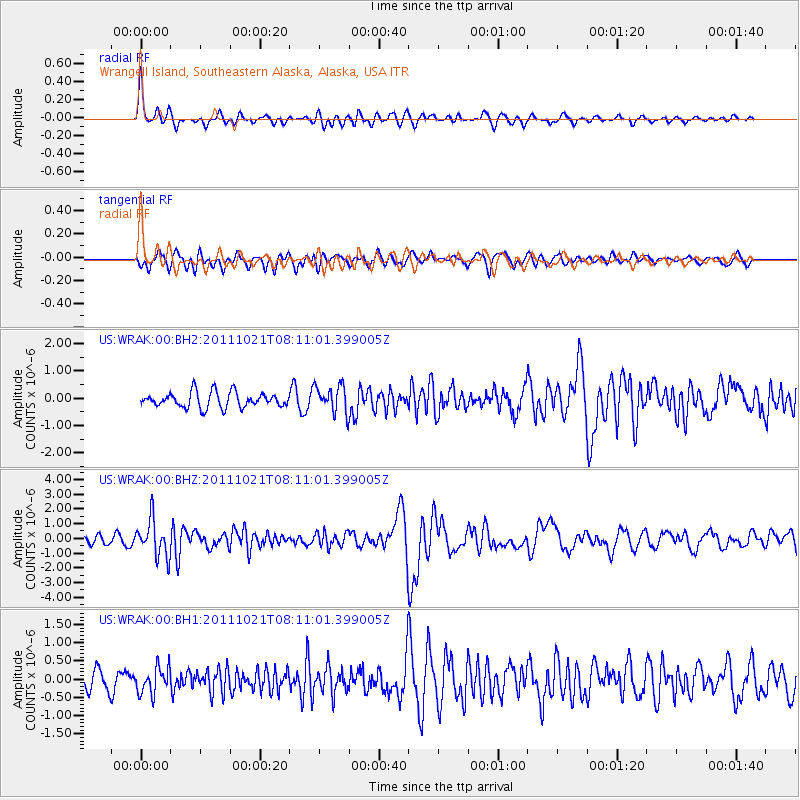
WRAK Wrangell Island, Southeastern Alaska, Alaska, USA - Earthquake Result Viewer
*The percent match for this event was below the threshold and hence no stack was calculated.
| Earthquake location: |
Hokkaido, Japan Region |
| Earthquake latitude/longitude: |
43.9/142.5 |
| Earthquake time(UTC): |
2011/10/21 (294) 08:02:37 GMT |
| Earthquake Depth: |
187 km |
| Earthquake Magnitude: |
5.9 MB, 6.1 MW, 6.1 MW |
| Earthquake Catalog/Contributor: |
WHDF/NEIC |
|
| Network: |
US United States National Seismic Network |
| Station: |
WRAK Wrangell Island, Southeastern Alaska, Alaska, USA |
| Lat/Lon: |
56.42 N/132.35 W |
| Elevation: |
81 m |
|
| Distance: |
52.5 deg |
| Az: |
44.232 deg |
| Baz: |
294.831 deg |
| Ray Param: |
$rayparam |
*The percent match for this event was below the threshold and hence was not used in the summary stack. |
|
| Radial Match: |
71.58022 % |
| Radial Bump: |
400 |
| Transverse Match: |
61.617447 % |
| Transverse Bump: |
400 |
| SOD ConfigId: |
558545 |
| Insert Time: |
2013-09-19 04:37:41.207 +0000 |
| GWidth: |
2.5 |
| Max Bumps: |
400 |
| Tol: |
0.001 |
|
Signal To Noise
| Channel | StoN | STA | LTA |
| US:WRAK:00:BHZ:20111021T08:11:01.399005Z | 3.2327747 | 1.2468473E-6 | 3.8568953E-7 |
| US:WRAK:00:BH1:20111021T08:11:01.399005Z | 1.4402938 | 3.64058E-7 | 2.5276648E-7 |
| US:WRAK:00:BH2:20111021T08:11:01.399005Z | 1.8118521 | 5.075899E-7 | 2.8014975E-7 |
| Arrivals |
| Ps | |
| PpPs | |
| PsPs/PpSs | |


