You are here: Home > Network List > II - Global Seismograph Network (GSN - IRIS/IDA) Stations List
> Station EFI Mount Kent, East Falkland Island > Earthquake Result Viewer
EFI Mount Kent, East Falkland Island - Earthquake Result Viewer
| Earthquake location: |
Kermadec Islands Region |
| Earthquake latitude/longitude: |
-29.0/-176.2 |
| Earthquake time(UTC): |
2011/10/21 (294) 17:57:16 GMT |
| Earthquake Depth: |
33 km |
| Earthquake Magnitude: |
6.4 MB, 7.5 MS, 7.4 MW, 7.4 MW |
| Earthquake Catalog/Contributor: |
WHDF/NEIC |
|
| Network: |
II Global Seismograph Network (GSN - IRIS/IDA) |
| Station: |
EFI Mount Kent, East Falkland Island |
| Lat/Lon: |
51.68 S/58.06 W |
| Elevation: |
110 m |
|
| Distance: |
83.1 deg |
| Az: |
146.435 deg |
| Baz: |
231.064 deg |
| Ray Param: |
0.046368703 |
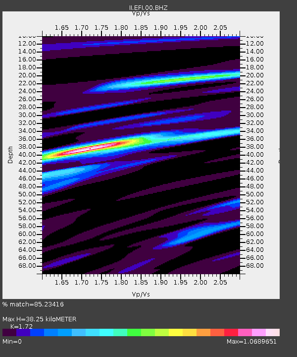
| Estimated Moho Depth: |
38.25 km |
| Estimated Crust Vp/Vs: |
1.72 |
| Assumed Crust Vp: |
6.472 km/s |
| Estimated Crust Vs: |
3.763 km/s |
| Estimated Crust Poisson's Ratio: |
0.24 |
|
| Radial Match: |
85.23416 % |
| Radial Bump: |
316 |
| Transverse Match: |
67.89702 % |
| Transverse Bump: |
400 |
| SOD ConfigId: |
558545 |
| Insert Time: |
2013-09-19 04:38:49.084 +0000 |
| GWidth: |
2.5 |
| Max Bumps: |
400 |
| Tol: |
0.001 |
|

Signal To Noise
| Channel | StoN | STA | LTA |
| II:EFI:00:BHZ:20111021T18:09:07.469019Z | 3.1425903 | 6.690961E-6 | 2.129123E-6 |
| II:EFI:00:BH1:20111021T18:09:07.469019Z | 2.2332678 | 3.081524E-6 | 1.3798274E-6 |
| II:EFI:00:BH2:20111021T18:09:07.469019Z | 0.80140716 | 1.389209E-6 | 1.7334621E-6 |
| Arrivals |
| Ps | 4.4 SECOND |
| PpPs | 16 SECOND |
| PsPs/PpSs | 20 SECOND |


