You are here: Home > Network List > IU - Global Seismograph Network (GSN - IRIS/USGS) Stations List
> Station GUMO Guam, Mariana Islands > Earthquake Result Viewer
GUMO Guam, Mariana Islands - Earthquake Result Viewer
| Earthquake location: |
Kermadec Islands Region |
| Earthquake latitude/longitude: |
-29.0/-176.2 |
| Earthquake time(UTC): |
2011/10/21 (294) 17:57:16 GMT |
| Earthquake Depth: |
33 km |
| Earthquake Magnitude: |
6.4 MB, 7.5 MS, 7.4 MW, 7.4 MW |
| Earthquake Catalog/Contributor: |
WHDF/NEIC |
|
| Network: |
IU Global Seismograph Network (GSN - IRIS/USGS) |
| Station: |
GUMO Guam, Mariana Islands |
| Lat/Lon: |
13.59 N/144.87 E |
| Elevation: |
170 m |
|
| Distance: |
56.6 deg |
| Az: |
313.008 deg |
| Baz: |
138.789 deg |
| Ray Param: |
0.06397414 |
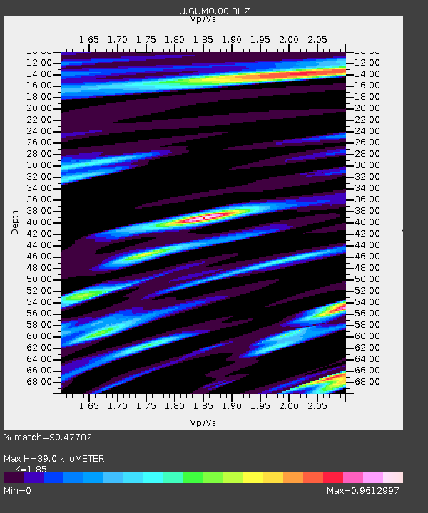
| Estimated Moho Depth: |
39.0 km |
| Estimated Crust Vp/Vs: |
1.85 |
| Assumed Crust Vp: |
4.802 km/s |
| Estimated Crust Vs: |
2.596 km/s |
| Estimated Crust Poisson's Ratio: |
0.29 |
|
| Radial Match: |
90.47782 % |
| Radial Bump: |
400 |
| Transverse Match: |
77.99787 % |
| Transverse Bump: |
400 |
| SOD ConfigId: |
558545 |
| Insert Time: |
2013-09-19 04:39:21.901 +0000 |
| GWidth: |
2.5 |
| Max Bumps: |
400 |
| Tol: |
0.001 |
|

Signal To Noise
| Channel | StoN | STA | LTA |
| IU:GUMO:00:BHZ:20111021T18:06:25.019006Z | 6.030604 | 5.319866E-6 | 8.8214483E-7 |
| IU:GUMO:00:BH1:20111021T18:06:25.019006Z | 3.0464208 | 2.5610493E-6 | 8.4067483E-7 |
| IU:GUMO:00:BH2:20111021T18:06:25.019006Z | 3.5257368 | 2.2299891E-6 | 6.324888E-7 |
| Arrivals |
| Ps | 7.1 SECOND |
| PpPs | 23 SECOND |
| PsPs/PpSs | 30 SECOND |


