You are here: Home > Network List > IU - Global Seismograph Network (GSN - IRIS/USGS) Stations List
> Station JOHN Johnston Island, USA > Earthquake Result Viewer
JOHN Johnston Island, USA - Earthquake Result Viewer
| Earthquake location: |
Kermadec Islands Region |
| Earthquake latitude/longitude: |
-29.0/-176.2 |
| Earthquake time(UTC): |
2011/10/21 (294) 17:57:16 GMT |
| Earthquake Depth: |
33 km |
| Earthquake Magnitude: |
6.4 MB, 7.5 MS, 7.4 MW, 7.4 MW |
| Earthquake Catalog/Contributor: |
WHDF/NEIC |
|
| Network: |
IU Global Seismograph Network (GSN - IRIS/USGS) |
| Station: |
JOHN Johnston Island, USA |
| Lat/Lon: |
16.73 N/169.53 W |
| Elevation: |
2.0 m |
|
| Distance: |
45.9 deg |
| Az: |
8.965 deg |
| Baz: |
188.191 deg |
| Ray Param: |
0.07090355 |
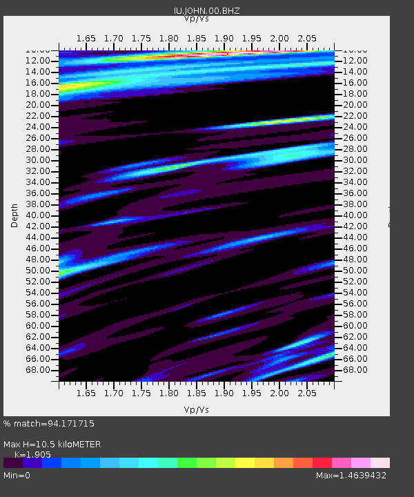
| Estimated Moho Depth: |
10.5 km |
| Estimated Crust Vp/Vs: |
1.90 |
| Assumed Crust Vp: |
4.24 km/s |
| Estimated Crust Vs: |
2.226 km/s |
| Estimated Crust Poisson's Ratio: |
0.31 |
|
| Radial Match: |
94.171715 % |
| Radial Bump: |
382 |
| Transverse Match: |
81.07255 % |
| Transverse Bump: |
400 |
| SOD ConfigId: |
558545 |
| Insert Time: |
2013-09-19 04:39:26.363 +0000 |
| GWidth: |
2.5 |
| Max Bumps: |
400 |
| Tol: |
0.001 |
|

Signal To Noise
| Channel | StoN | STA | LTA |
| IU:JOHN:00:BHZ:20111021T18:05:05.044Z | 6.335582 | 1.3684183E-5 | 2.1598935E-6 |
| IU:JOHN:00:BH1:20111021T18:05:05.044Z | 1.9604112 | 6.9427483E-6 | 3.5414757E-6 |
| IU:JOHN:00:BH2:20111021T18:05:05.044Z | 2.098283 | 6.222739E-6 | 2.9656337E-6 |
| Arrivals |
| Ps | 2.3 SECOND |
| PpPs | 7.0 SECOND |
| PsPs/PpSs | 9.3 SECOND |


