You are here: Home > Network List > IU - Global Seismograph Network (GSN - IRIS/USGS) Stations List
> Station PAYG Puerto Ayora, Galapagos Islands > Earthquake Result Viewer
PAYG Puerto Ayora, Galapagos Islands - Earthquake Result Viewer
| Earthquake location: |
Kermadec Islands Region |
| Earthquake latitude/longitude: |
-29.0/-176.2 |
| Earthquake time(UTC): |
2011/10/21 (294) 17:57:16 GMT |
| Earthquake Depth: |
33 km |
| Earthquake Magnitude: |
6.4 MB, 7.5 MS, 7.4 MW, 7.4 MW |
| Earthquake Catalog/Contributor: |
WHDF/NEIC |
|
| Network: |
IU Global Seismograph Network (GSN - IRIS/USGS) |
| Station: |
PAYG Puerto Ayora, Galapagos Islands |
| Lat/Lon: |
0.67 S/90.29 W |
| Elevation: |
270 m |
|
| Distance: |
86.1 deg |
| Az: |
88.633 deg |
| Baz: |
241.147 deg |
| Ray Param: |
0.04422772 |
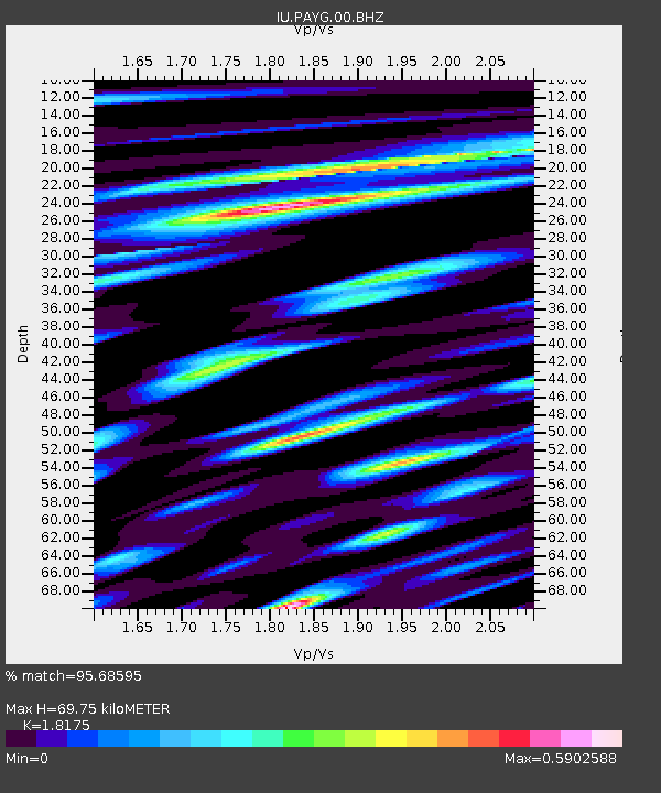
| Estimated Moho Depth: |
69.75 km |
| Estimated Crust Vp/Vs: |
1.82 |
| Assumed Crust Vp: |
4.802 km/s |
| Estimated Crust Vs: |
2.642 km/s |
| Estimated Crust Poisson's Ratio: |
0.28 |
|
| Radial Match: |
95.68595 % |
| Radial Bump: |
357 |
| Transverse Match: |
87.48948 % |
| Transverse Bump: |
400 |
| SOD ConfigId: |
558545 |
| Insert Time: |
2013-09-19 04:39:48.855 +0000 |
| GWidth: |
2.5 |
| Max Bumps: |
400 |
| Tol: |
0.001 |
|
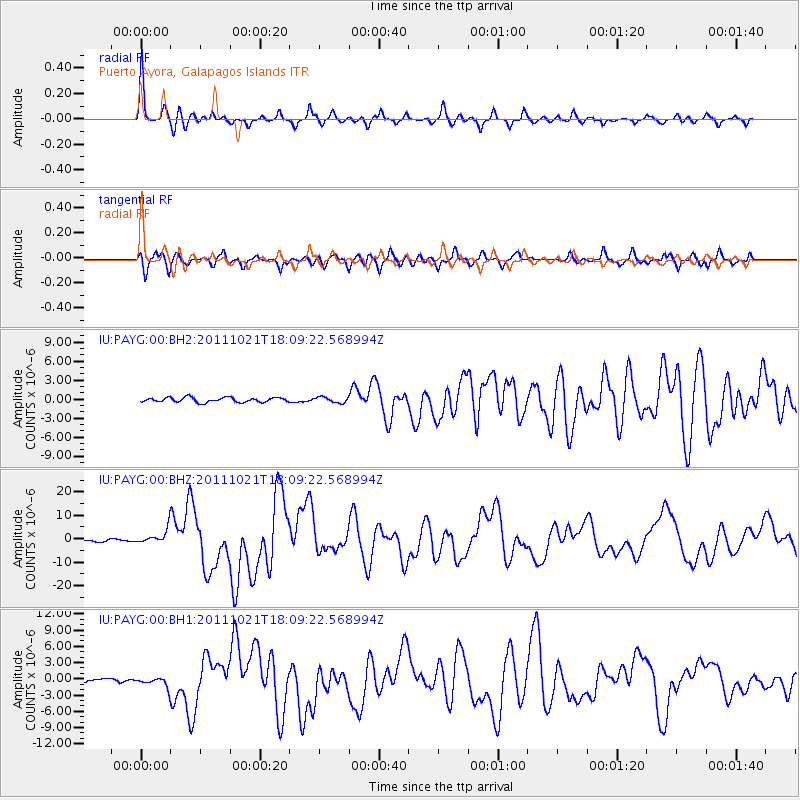
Signal To Noise
| Channel | StoN | STA | LTA |
| IU:PAYG:00:BHZ:20111021T18:09:22.568994Z | 8.289589 | 3.1224004E-6 | 3.7666527E-7 |
| IU:PAYG:00:BH1:20111021T18:09:22.568994Z | 3.2534273 | 8.7515883E-7 | 2.68996E-7 |
| IU:PAYG:00:BH2:20111021T18:09:22.568994Z | 1.2066242 | 4.4535054E-7 | 3.6908804E-7 |
| Arrivals |
| Ps | 12 SECOND |
| PpPs | 40 SECOND |
| PsPs/PpSs | 52 SECOND |


