You are here: Home > Network List > IU - Global Seismograph Network (GSN - IRIS/USGS) Stations List
> Station PMG Port Moresby, New Guinea > Earthquake Result Viewer
PMG Port Moresby, New Guinea - Earthquake Result Viewer
| Earthquake location: |
Kermadec Islands Region |
| Earthquake latitude/longitude: |
-29.0/-176.2 |
| Earthquake time(UTC): |
2011/10/21 (294) 17:57:16 GMT |
| Earthquake Depth: |
33 km |
| Earthquake Magnitude: |
6.4 MB, 7.5 MS, 7.4 MW, 7.4 MW |
| Earthquake Catalog/Contributor: |
WHDF/NEIC |
|
| Network: |
IU Global Seismograph Network (GSN - IRIS/USGS) |
| Station: |
PMG Port Moresby, New Guinea |
| Lat/Lon: |
9.40 S/147.16 E |
| Elevation: |
90 m |
|
| Distance: |
39.4 deg |
| Az: |
292.172 deg |
| Baz: |
124.696 deg |
| Ray Param: |
0.07491749 |
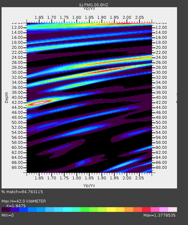
| Estimated Moho Depth: |
42.0 km |
| Estimated Crust Vp/Vs: |
1.65 |
| Assumed Crust Vp: |
6.122 km/s |
| Estimated Crust Vs: |
3.716 km/s |
| Estimated Crust Poisson's Ratio: |
0.21 |
|
| Radial Match: |
94.763115 % |
| Radial Bump: |
400 |
| Transverse Match: |
81.14431 % |
| Transverse Bump: |
400 |
| SOD ConfigId: |
558545 |
| Insert Time: |
2013-09-19 04:39:50.279 +0000 |
| GWidth: |
2.5 |
| Max Bumps: |
400 |
| Tol: |
0.001 |
|

Signal To Noise
| Channel | StoN | STA | LTA |
| IU:PMG:00:BHZ:20111021T18:04:12.669Z | 8.505844 | 2.9683856E-6 | 3.4898193E-7 |
| IU:PMG:00:BH1:20111021T18:04:12.669Z | 2.8076217 | 1.2057494E-6 | 4.2945578E-7 |
| IU:PMG:00:BH2:20111021T18:04:12.669Z | 5.6302586 | 1.5651469E-6 | 2.7798848E-7 |
| Arrivals |
| Ps | 4.8 SECOND |
| PpPs | 17 SECOND |
| PsPs/PpSs | 22 SECOND |


