You are here: Home > Network List > IU - Global Seismograph Network (GSN - IRIS/USGS) Stations List
> Station TUC Tucson, Arizona > Earthquake Result Viewer
TUC Tucson, Arizona - Earthquake Result Viewer
| Earthquake location: |
Kermadec Islands Region |
| Earthquake latitude/longitude: |
-29.0/-176.2 |
| Earthquake time(UTC): |
2011/10/21 (294) 17:57:16 GMT |
| Earthquake Depth: |
33 km |
| Earthquake Magnitude: |
6.4 MB, 7.5 MS, 7.4 MW, 7.4 MW |
| Earthquake Catalog/Contributor: |
WHDF/NEIC |
|
| Network: |
IU Global Seismograph Network (GSN - IRIS/USGS) |
| Station: |
TUC Tucson, Arizona |
| Lat/Lon: |
32.31 N/110.78 W |
| Elevation: |
910 m |
|
| Distance: |
87.0 deg |
| Az: |
50.47 deg |
| Baz: |
232.934 deg |
| Ray Param: |
0.0435707 |
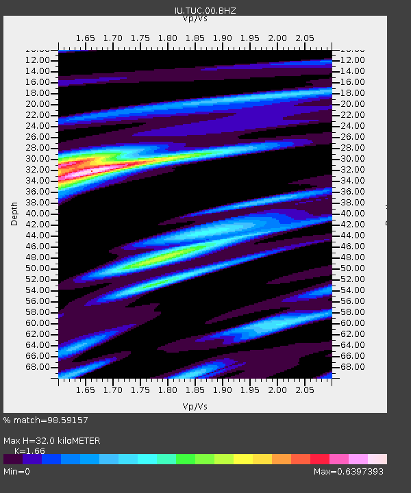
| Estimated Moho Depth: |
32.0 km |
| Estimated Crust Vp/Vs: |
1.66 |
| Assumed Crust Vp: |
6.276 km/s |
| Estimated Crust Vs: |
3.781 km/s |
| Estimated Crust Poisson's Ratio: |
0.22 |
|
| Radial Match: |
98.59157 % |
| Radial Bump: |
299 |
| Transverse Match: |
94.3557 % |
| Transverse Bump: |
400 |
| SOD ConfigId: |
558545 |
| Insert Time: |
2013-09-19 04:40:19.269 +0000 |
| GWidth: |
2.5 |
| Max Bumps: |
400 |
| Tol: |
0.001 |
|
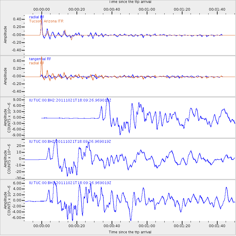
Signal To Noise
| Channel | StoN | STA | LTA |
| IU:TUC:00:BHZ:20111021T18:09:26.969019Z | 37.23785 | 6.7183455E-6 | 1.8041712E-7 |
| IU:TUC:00:BH1:20111021T18:09:26.969019Z | 19.876062 | 1.4349268E-6 | 7.219372E-8 |
| IU:TUC:00:BH2:20111021T18:09:26.969019Z | 30.587996 | 2.1974329E-6 | 7.1839715E-8 |
| Arrivals |
| Ps | 3.4 SECOND |
| PpPs | 13 SECOND |
| PsPs/PpSs | 17 SECOND |


