You are here: Home > Network List > US - United States National Seismic Network Stations List
> Station MVCO Mesa Verde, Colorado, USA > Earthquake Result Viewer
MVCO Mesa Verde, Colorado, USA - Earthquake Result Viewer
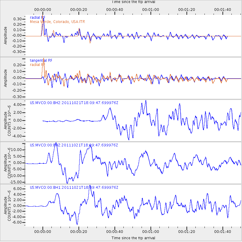
| Earthquake location: |
Kermadec Islands Region |
| Earthquake latitude/longitude: |
-29.0/-176.2 |
| Earthquake time(UTC): |
2011/10/21 (294) 17:57:16 GMT |
| Earthquake Depth: |
33 km |
| Earthquake Magnitude: |
6.4 MB, 7.5 MS, 7.4 MW, 7.4 MW |
| Earthquake Catalog/Contributor: |
WHDF/NEIC |
|
| Network: |
US United States National Seismic Network |
| Station: |
MVCO Mesa Verde, Colorado, USA |
| Lat/Lon: |
37.21 N/108.50 W |
| Elevation: |
2170 m |
|
| Distance: |
91.5 deg |
| Az: |
47.656 deg |
| Baz: |
234.196 deg |
| Ray Param: |
0.04159676 |
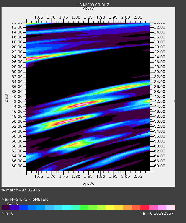
| Estimated Moho Depth: |
24.75 km |
| Estimated Crust Vp/Vs: |
1.60 |
| Assumed Crust Vp: |
6.476 km/s |
| Estimated Crust Vs: |
4.047 km/s |
| Estimated Crust Poisson's Ratio: |
0.18 |
|
| Radial Match: |
97.02975 % |
| Radial Bump: |
400 |
| Transverse Match: |
82.21826 % |
| Transverse Bump: |
400 |
| SOD ConfigId: |
558545 |
| Insert Time: |
2013-09-19 04:41:16.031 +0000 |
| GWidth: |
2.5 |
| Max Bumps: |
400 |
| Tol: |
0.001 |
|
Signal To Noise
| Channel | StoN | STA | LTA |
| US:MVCO:00:BHZ:20111021T18:09:47.699976Z | 25.243946 | 3.4083341E-6 | 1.350159E-7 |
| US:MVCO:00:BH1:20111021T18:09:47.699976Z | 7.6070695 | 8.453124E-7 | 1.1112195E-7 |
| US:MVCO:00:BH2:20111021T18:09:47.699976Z | 4.4965253 | 6.025335E-7 | 1.3399979E-7 |
| Arrivals |
| Ps | 2.3 SECOND |
| PpPs | 9.7 SECOND |
| PsPs/PpSs | 12 SECOND |


