You are here: Home > Network List > CN - Canadian National Seismograph Network Stations List
> Station INK INUVIK, NT, CANADA.ANADA > Earthquake Result Viewer
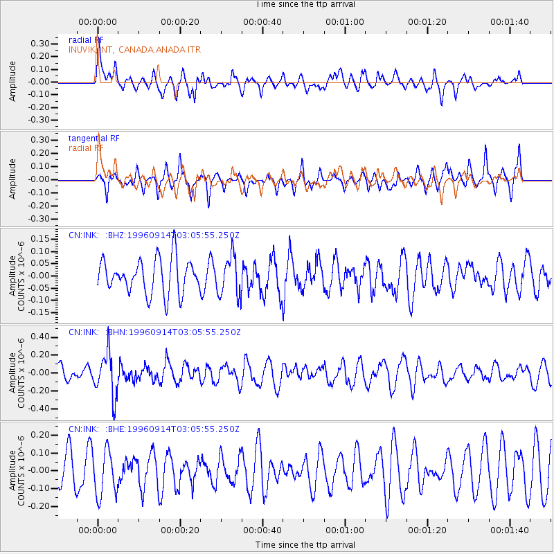
INK INUVIK, NT, CANADA.ANADA - Earthquake Result Viewer
*The percent match for this event was below the threshold and hence no stack was calculated.
| Earthquake location: |
Minahassa Peninsula, Sulawesi |
| Earthquake latitude/longitude: |
-0.0/122.8 |
| Earthquake time(UTC): |
1996/09/14 (258) 02:53:24 GMT |
| Earthquake Depth: |
181 km |
| Earthquake Magnitude: |
5.5 MB |
| Earthquake Catalog/Contributor: |
WHDF/NEIC |
|
| Network: |
CN Canadian National Seismograph Network |
| Station: |
INK INUVIK, NT, CANADA.ANADA |
| Lat/Lon: |
68.31 N/133.52 W |
| Elevation: |
40 m |
|
| Distance: |
95.1 deg |
| Az: |
21.262 deg |
| Baz: |
282.735 deg |
| Ray Param: |
$rayparam |
*The percent match for this event was below the threshold and hence was not used in the summary stack. |
|
| Radial Match: |
63.99478 % |
| Radial Bump: |
400 |
| Transverse Match: |
39.082767 % |
| Transverse Bump: |
295 |
| SOD ConfigId: |
4480 |
| Insert Time: |
2010-02-27 06:29:56.736 +0000 |
| GWidth: |
2.5 |
| Max Bumps: |
400 |
| Tol: |
0.001 |
|
Signal To Noise
| Channel | StoN | STA | LTA |
| CN:INK: :BHN:19960914T03:05:55.250Z | 2.4405727 | 2.4383786E-7 | 9.9910096E-8 |
| CN:INK: :BHE:19960914T03:05:55.250Z | 1.4731361 | 1.2824646E-7 | 8.7056755E-8 |
| CN:INK: :BHZ:19960914T03:05:55.250Z | 1.1789982 | 8.3496005E-8 | 7.0819446E-8 |
| Arrivals |
| Ps | |
| PpPs | |
| PsPs/PpSs | |


