You are here: Home > Network List > II - Global Seismograph Network (GSN - IRIS/IDA) Stations List
> Station CMLA Cha de Macela, Sao Miguel Island, Azores > Earthquake Result Viewer
CMLA Cha de Macela, Sao Miguel Island, Azores - Earthquake Result Viewer
| Earthquake location: |
Turkey |
| Earthquake latitude/longitude: |
38.7/43.5 |
| Earthquake time(UTC): |
2011/10/23 (296) 10:41:22 GMT |
| Earthquake Depth: |
16 km |
| Earthquake Magnitude: |
6.9 MB, 7.3 MS, 7.3 MW, 7.1 MW |
| Earthquake Catalog/Contributor: |
WHDF/NEIC |
|
| Network: |
II Global Seismograph Network (GSN - IRIS/IDA) |
| Station: |
CMLA Cha de Macela, Sao Miguel Island, Azores |
| Lat/Lon: |
37.76 N/25.52 W |
| Elevation: |
429 m |
|
| Distance: |
53.0 deg |
| Az: |
292.092 deg |
| Baz: |
66.141 deg |
| Ray Param: |
0.0663734 |
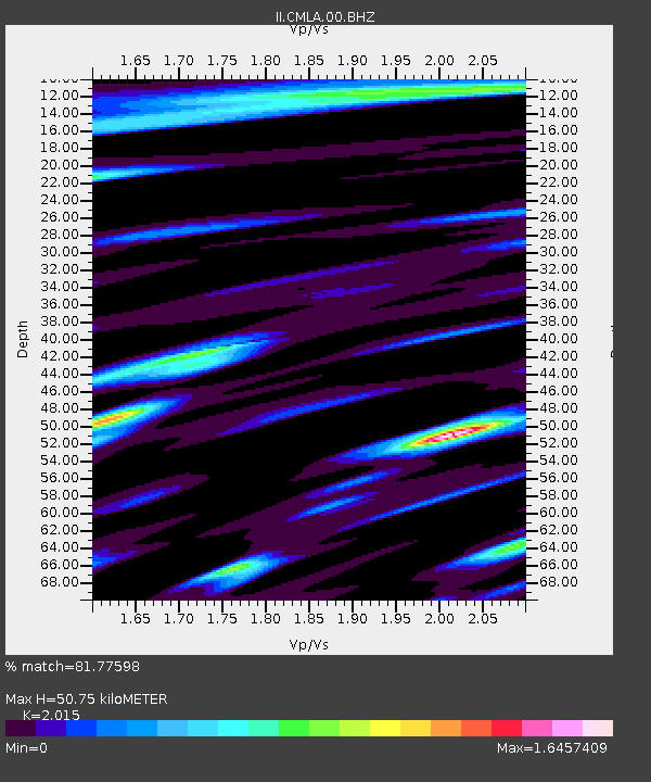
| Estimated Moho Depth: |
50.75 km |
| Estimated Crust Vp/Vs: |
2.02 |
| Assumed Crust Vp: |
4.802 km/s |
| Estimated Crust Vs: |
2.383 km/s |
| Estimated Crust Poisson's Ratio: |
0.34 |
|
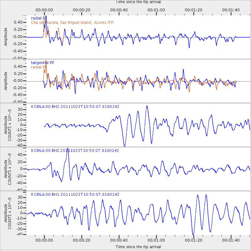
| Radial Match: |
81.77598 % |
| Radial Bump: |
400 |
| Transverse Match: |
78.46612 % |
| Transverse Bump: |
397 |
| SOD ConfigId: |
558545 |
| Insert Time: |
2013-09-19 04:43:01.443 +0000 |
| GWidth: |
2.5 |
| Max Bumps: |
400 |
| Tol: |
0.001 |
|
Signal To Noise
| Channel | StoN | STA | LTA |
| II:CMLA:00:BHZ:20111023T10:50:07.919014Z | 10.618113 | 1.0892451E-5 | 1.0258368E-6 |
| II:CMLA:00:BH1:20111023T10:50:07.919014Z | 1.6275721 | 3.2169635E-6 | 1.9765414E-6 |
| II:CMLA:00:BH2:20111023T10:50:07.919014Z | 2.944095 | 5.4537013E-6 | 1.8524204E-6 |
| Arrivals |
| Ps | 11 SECOND |
| PpPs | 31 SECOND |
| PsPs/PpSs | 42 SECOND |


