You are here: Home > Network List > IU - Global Seismograph Network (GSN - IRIS/USGS) Stations List
> Station TATO Taipei, Taiwan > Earthquake Result Viewer
TATO Taipei, Taiwan - Earthquake Result Viewer

| Earthquake location: |
Turkey |
| Earthquake latitude/longitude: |
38.7/43.5 |
| Earthquake time(UTC): |
2011/10/23 (296) 10:41:22 GMT |
| Earthquake Depth: |
16 km |
| Earthquake Magnitude: |
6.9 MB, 7.3 MS, 7.3 MW, 7.1 MW |
| Earthquake Catalog/Contributor: |
WHDF/NEIC |
|
| Network: |
IU Global Seismograph Network (GSN - IRIS/USGS) |
| Station: |
TATO Taipei, Taiwan |
| Lat/Lon: |
24.97 N/121.50 E |
| Elevation: |
160 m |
|
| Distance: |
65.8 deg |
| Az: |
76.646 deg |
| Baz: |
303.009 deg |
| Ray Param: |
0.05799867 |
| Estimated Moho Depth: |
32.0 km |
| Estimated Crust Vp/Vs: |
1.63 |
| Assumed Crust Vp: |
6.289 km/s |
| Estimated Crust Vs: |
3.852 km/s |
| Estimated Crust Poisson's Ratio: |
0.20 |
|
| Radial Match: |
96.77578 % |
| Radial Bump: |
331 |
| Transverse Match: |
91.38291 % |
| Transverse Bump: |
400 |
| SOD ConfigId: |
558545 |
| Insert Time: |
2013-09-19 04:44:14.348 +0000 |
| GWidth: |
2.5 |
| Max Bumps: |
400 |
| Tol: |
0.001 |
|
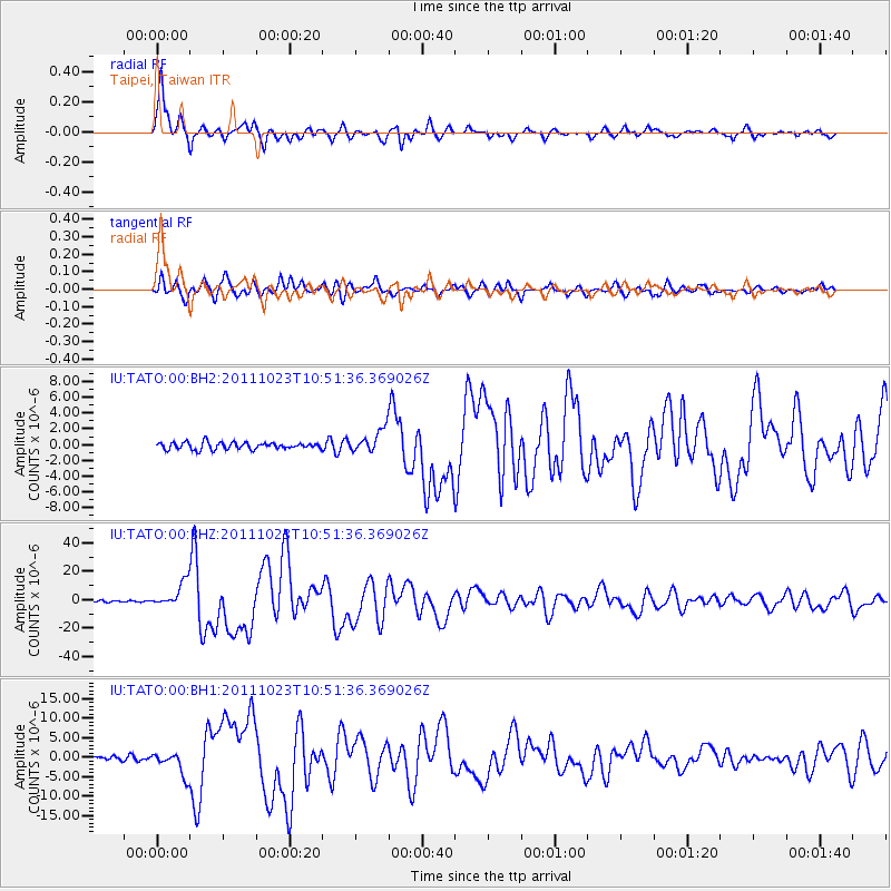
Signal To Noise
| Channel | StoN | STA | LTA |
| IU:TATO:00:BHZ:20111023T10:51:36.369026Z | 14.88001 | 8.672357E-6 | 5.8281927E-7 |
| IU:TATO:00:BH1:20111023T10:51:36.369026Z | 4.493558 | 3.0116091E-6 | 6.702059E-7 |
| IU:TATO:00:BH2:20111023T10:51:36.369026Z | 3.109888 | 1.3385759E-6 | 4.3042573E-7 |
| Arrivals |
| Ps | 3.4 SECOND |
| PpPs | 13 SECOND |
| PsPs/PpSs | 16 SECOND |


