You are here: Home > Network List > US - United States National Seismic Network Stations List
> Station ERPA Erie, Pennsylvania, USA > Earthquake Result Viewer
ERPA Erie, Pennsylvania, USA - Earthquake Result Viewer
| Earthquake location: |
Turkey |
| Earthquake latitude/longitude: |
38.7/43.5 |
| Earthquake time(UTC): |
2011/10/23 (296) 10:41:22 GMT |
| Earthquake Depth: |
16 km |
| Earthquake Magnitude: |
6.9 MB, 7.3 MS, 7.3 MW, 7.1 MW |
| Earthquake Catalog/Contributor: |
WHDF/NEIC |
|
| Network: |
US United States National Seismic Network |
| Station: |
ERPA Erie, Pennsylvania, USA |
| Lat/Lon: |
42.12 N/79.99 W |
| Elevation: |
306 m |
|
| Distance: |
84.5 deg |
| Az: |
321.448 deg |
| Baz: |
40.938 deg |
| Ray Param: |
0.045393836 |
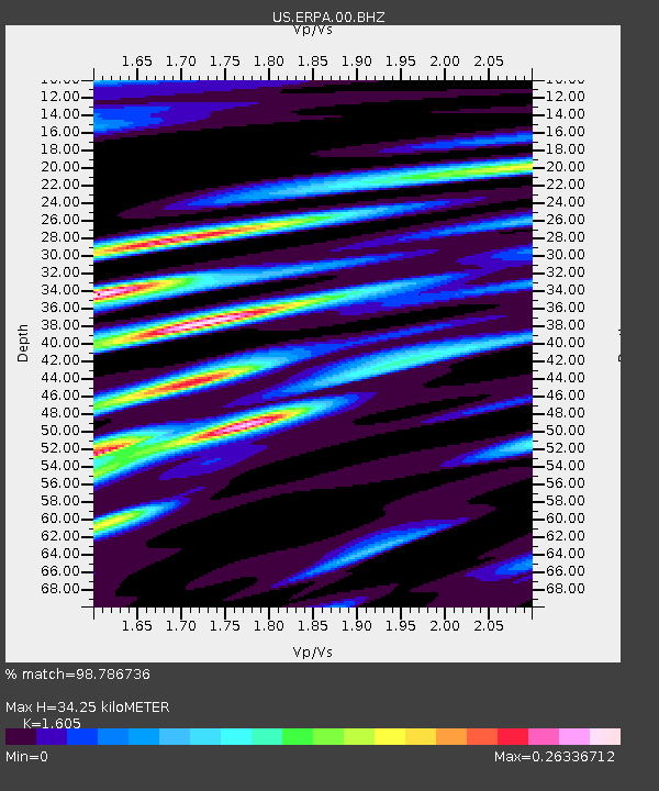
| Estimated Moho Depth: |
34.25 km |
| Estimated Crust Vp/Vs: |
1.61 |
| Assumed Crust Vp: |
6.419 km/s |
| Estimated Crust Vs: |
4.0 km/s |
| Estimated Crust Poisson's Ratio: |
0.18 |
|
| Radial Match: |
98.786736 % |
| Radial Bump: |
289 |
| Transverse Match: |
95.20025 % |
| Transverse Bump: |
400 |
| SOD ConfigId: |
558545 |
| Insert Time: |
2013-09-19 04:45:13.172 +0000 |
| GWidth: |
2.5 |
| Max Bumps: |
400 |
| Tol: |
0.001 |
|

Signal To Noise
| Channel | StoN | STA | LTA |
| US:ERPA:00:BHZ:20111023T10:53:23.698982Z | 82.087585 | 1.1041199E-5 | 1.345051E-7 |
| US:ERPA:00:BH1:20111023T10:53:23.698982Z | 20.797253 | 3.0006493E-6 | 1.4428105E-7 |
| US:ERPA:00:BH2:20111023T10:53:23.698982Z | 15.536188 | 2.1744272E-6 | 1.3995887E-7 |
| Arrivals |
| Ps | 3.3 SECOND |
| PpPs | 14 SECOND |
| PsPs/PpSs | 17 SECOND |


