You are here: Home > Network List > US - United States National Seismic Network Stations List
> Station JFWS Jewell Farm, Wisconsin, USA > Earthquake Result Viewer
JFWS Jewell Farm, Wisconsin, USA - Earthquake Result Viewer
| Earthquake location: |
Turkey |
| Earthquake latitude/longitude: |
38.7/43.5 |
| Earthquake time(UTC): |
2011/10/23 (296) 10:41:22 GMT |
| Earthquake Depth: |
16 km |
| Earthquake Magnitude: |
6.9 MB, 7.3 MS, 7.3 MW, 7.1 MW |
| Earthquake Catalog/Contributor: |
WHDF/NEIC |
|
| Network: |
US United States National Seismic Network |
| Station: |
JFWS Jewell Farm, Wisconsin, USA |
| Lat/Lon: |
42.91 N/90.25 W |
| Elevation: |
335 m |
|
| Distance: |
88.6 deg |
| Az: |
327.944 deg |
| Baz: |
34.412 deg |
| Ray Param: |
0.0424882 |
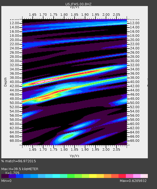
| Estimated Moho Depth: |
39.5 km |
| Estimated Crust Vp/Vs: |
1.71 |
| Assumed Crust Vp: |
6.53 km/s |
| Estimated Crust Vs: |
3.83 km/s |
| Estimated Crust Poisson's Ratio: |
0.24 |
|
| Radial Match: |
96.972015 % |
| Radial Bump: |
400 |
| Transverse Match: |
88.504005 % |
| Transverse Bump: |
400 |
| SOD ConfigId: |
558545 |
| Insert Time: |
2013-09-19 04:45:38.442 +0000 |
| GWidth: |
2.5 |
| Max Bumps: |
400 |
| Tol: |
0.001 |
|

Signal To Noise
| Channel | StoN | STA | LTA |
| US:JFWS:00:BHZ:20111023T10:53:43.274971Z | 57.873024 | 5.9954245E-6 | 1.03596186E-7 |
| US:JFWS:00:BH1:20111023T10:53:43.274971Z | 18.522095 | 1.6856716E-6 | 9.100869E-8 |
| US:JFWS:00:BH2:20111023T10:53:43.274971Z | 11.200989 | 1.0429817E-6 | 9.311515E-8 |
| Arrivals |
| Ps | 4.4 SECOND |
| PpPs | 16 SECOND |
| PsPs/PpSs | 20 SECOND |


