You are here: Home > Network List > US - United States National Seismic Network Stations List
> Station LONY Lake Ozonia, New York, USA > Earthquake Result Viewer
LONY Lake Ozonia, New York, USA - Earthquake Result Viewer
| Earthquake location: |
Turkey |
| Earthquake latitude/longitude: |
38.7/43.5 |
| Earthquake time(UTC): |
2011/10/23 (296) 10:41:22 GMT |
| Earthquake Depth: |
16 km |
| Earthquake Magnitude: |
6.9 MB, 7.3 MS, 7.3 MW, 7.1 MW |
| Earthquake Catalog/Contributor: |
WHDF/NEIC |
|
| Network: |
US United States National Seismic Network |
| Station: |
LONY Lake Ozonia, New York, USA |
| Lat/Lon: |
44.62 N/74.58 W |
| Elevation: |
440 m |
|
| Distance: |
80.0 deg |
| Az: |
320.236 deg |
| Baz: |
44.477 deg |
| Ray Param: |
0.048539534 |
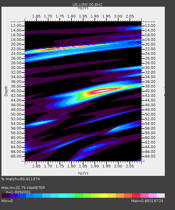
| Estimated Moho Depth: |
20.75 km |
| Estimated Crust Vp/Vs: |
1.81 |
| Assumed Crust Vp: |
6.419 km/s |
| Estimated Crust Vs: |
3.556 km/s |
| Estimated Crust Poisson's Ratio: |
0.28 |
|
| Radial Match: |
98.811874 % |
| Radial Bump: |
324 |
| Transverse Match: |
95.92445 % |
| Transverse Bump: |
400 |
| SOD ConfigId: |
558545 |
| Insert Time: |
2013-09-19 04:45:49.024 +0000 |
| GWidth: |
2.5 |
| Max Bumps: |
400 |
| Tol: |
0.001 |
|
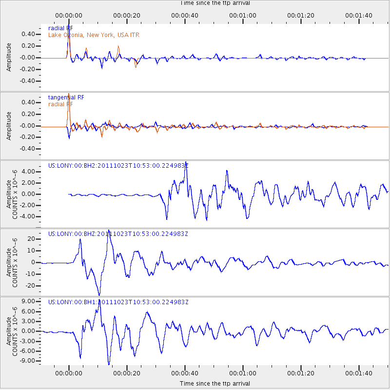
Signal To Noise
| Channel | StoN | STA | LTA |
| US:LONY:00:BHZ:20111023T10:53:00.224983Z | 50.347702 | 7.727716E-6 | 1.5348697E-7 |
| US:LONY:00:BH1:20111023T10:53:00.224983Z | 27.751453 | 2.9884557E-6 | 1.0768645E-7 |
| US:LONY:00:BH2:20111023T10:53:00.224983Z | 14.119051 | 1.5540795E-6 | 1.10069685E-7 |
| Arrivals |
| Ps | 2.7 SECOND |
| PpPs | 8.8 SECOND |
| PsPs/PpSs | 11 SECOND |


