You are here: Home > Network List > CN - Canadian National Seismograph Network Stations List
> Station INK INUVIK, NT, CANADA.ANADA > Earthquake Result Viewer
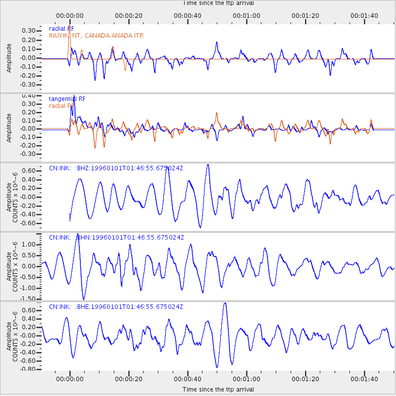
INK INUVIK, NT, CANADA.ANADA - Earthquake Result Viewer
*The percent match for this event was below the threshold and hence no stack was calculated.
| Earthquake location: |
Tonga Islands |
| Earthquake latitude/longitude: |
-20.3/-174.4 |
| Earthquake time(UTC): |
1996/01/01 (001) 01:34:15 GMT |
| Earthquake Depth: |
33 km |
| Earthquake Magnitude: |
5.8 MS, 5.3 MB |
| Earthquake Catalog/Contributor: |
WHDF/NEIC |
|
| Network: |
CN Canadian National Seismograph Network |
| Station: |
INK INUVIK, NT, CANADA.ANADA |
| Lat/Lon: |
68.31 N/133.52 W |
| Elevation: |
40 m |
|
| Distance: |
93.2 deg |
| Az: |
14.094 deg |
| Baz: |
217.932 deg |
| Ray Param: |
$rayparam |
*The percent match for this event was below the threshold and hence was not used in the summary stack. |
|
| Radial Match: |
48.149143 % |
| Radial Bump: |
400 |
| Transverse Match: |
59.39904 % |
| Transverse Bump: |
400 |
| SOD ConfigId: |
4480 |
| Insert Time: |
2010-02-27 06:30:50.648 +0000 |
| GWidth: |
2.5 |
| Max Bumps: |
400 |
| Tol: |
0.001 |
|
Signal To Noise
| Channel | StoN | STA | LTA |
| CN:INK: :BHN:19960101T01:46:55.675024Z | 3.4091978 | 9.2678795E-7 | 2.7184927E-7 |
| CN:INK: :BHE:19960101T01:46:55.675024Z | 0.71507514 | 2.8300067E-7 | 3.9576355E-7 |
| CN:INK: :BHZ:19960101T01:46:55.675024Z | 1.5362672 | 3.831158E-7 | 2.4938097E-7 |
| Arrivals |
| Ps | |
| PpPs | |
| PsPs/PpSs | |


