You are here: Home > Network List > US - United States National Seismic Network Stations List
> Station HAWA Hanford, Washington, USA > Earthquake Result Viewer
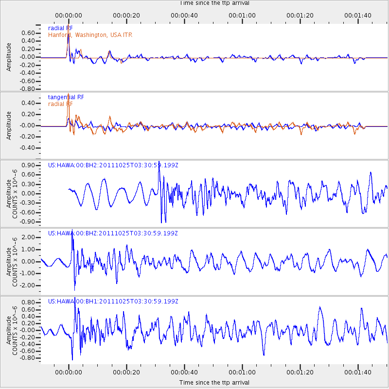
HAWA Hanford, Washington, USA - Earthquake Result Viewer
*The percent match for this event was below the threshold and hence no stack was calculated.
| Earthquake location: |
Fox Islands, Aleutian Islands |
| Earthquake latitude/longitude: |
52.2/-171.8 |
| Earthquake time(UTC): |
2011/10/25 (298) 03:24:49 GMT |
| Earthquake Depth: |
38 km |
| Earthquake Magnitude: |
5.9 MB, 5.3 MS, 5.7 MW, 5.7 MW |
| Earthquake Catalog/Contributor: |
WHDF/NEIC |
|
| Network: |
US United States National Seismic Network |
| Station: |
HAWA Hanford, Washington, USA |
| Lat/Lon: |
46.39 N/119.53 W |
| Elevation: |
364 m |
|
| Distance: |
34.0 deg |
| Az: |
78.523 deg |
| Baz: |
299.278 deg |
| Ray Param: |
$rayparam |
*The percent match for this event was below the threshold and hence was not used in the summary stack. |
|
| Radial Match: |
58.44339 % |
| Radial Bump: |
400 |
| Transverse Match: |
56.94999 % |
| Transverse Bump: |
400 |
| SOD ConfigId: |
558545 |
| Insert Time: |
2013-09-19 05:01:40.832 +0000 |
| GWidth: |
2.5 |
| Max Bumps: |
400 |
| Tol: |
0.001 |
|
Signal To Noise
| Channel | StoN | STA | LTA |
| US:HAWA:00:BHZ:20111025T03:30:59.199Z | 2.8891163 | 1.019094E-6 | 3.5273555E-7 |
| US:HAWA:00:BH1:20111025T03:30:59.199Z | 2.6644359 | 3.9285248E-7 | 1.4744302E-7 |
| US:HAWA:00:BH2:20111025T03:30:59.199Z | 1.7328038 | 4.305203E-7 | 2.4845298E-7 |
| Arrivals |
| Ps | |
| PpPs | |
| PsPs/PpSs | |


