You are here: Home > Network List > US - United States National Seismic Network Stations List
> Station WUAZ Wupatki, Arizona, USA > Earthquake Result Viewer
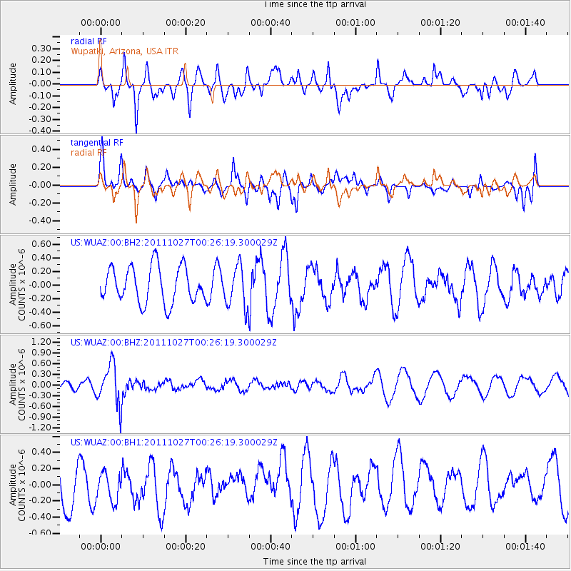
WUAZ Wupatki, Arizona, USA - Earthquake Result Viewer
*The percent match for this event was below the threshold and hence no stack was calculated.
| Earthquake location: |
Fiji Islands Region |
| Earthquake latitude/longitude: |
-17.9/-179.5 |
| Earthquake time(UTC): |
2011/10/27 (300) 00:15:24 GMT |
| Earthquake Depth: |
603 km |
| Earthquake Magnitude: |
6.0 MW, 5.3 MB, 6.0 MW |
| Earthquake Catalog/Contributor: |
WHDF/NEIC |
|
| Network: |
US United States National Seismic Network |
| Station: |
WUAZ Wupatki, Arizona, USA |
| Lat/Lon: |
35.52 N/111.37 W |
| Elevation: |
1592 m |
|
| Distance: |
83.6 deg |
| Az: |
49.641 deg |
| Baz: |
242.775 deg |
| Ray Param: |
$rayparam |
*The percent match for this event was below the threshold and hence was not used in the summary stack. |
|
| Radial Match: |
67.5241 % |
| Radial Bump: |
400 |
| Transverse Match: |
54.14437 % |
| Transverse Bump: |
400 |
| SOD ConfigId: |
558545 |
| Insert Time: |
2013-09-19 05:08:15.799 +0000 |
| GWidth: |
2.5 |
| Max Bumps: |
400 |
| Tol: |
0.001 |
|
Signal To Noise
| Channel | StoN | STA | LTA |
| US:WUAZ:00:BHZ:20111027T00:26:19.300029Z | 2.8679779 | 5.8202E-7 | 2.0293743E-7 |
| US:WUAZ:00:BH1:20111027T00:26:19.300029Z | 0.44429308 | 1.7446553E-7 | 3.9268116E-7 |
| US:WUAZ:00:BH2:20111027T00:26:19.300029Z | 1.162125 | 3.0868713E-7 | 2.6562302E-7 |
| Arrivals |
| Ps | |
| PpPs | |
| PsPs/PpSs | |


