You are here: Home > Network List > US - United States National Seismic Network Stations List
> Station WMOK Wichita Mountains, Oklahoma, USA > Earthquake Result Viewer
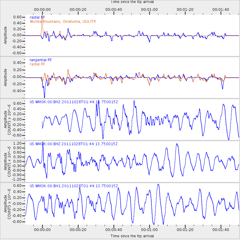
WMOK Wichita Mountains, Oklahoma, USA - Earthquake Result Viewer
*The percent match for this event was below the threshold and hence no stack was calculated.
| Earthquake location: |
Fox Islands, Aleutian Islands |
| Earthquake latitude/longitude: |
52.1/-171.6 |
| Earthquake time(UTC): |
2011/10/28 (301) 01:35:28 GMT |
| Earthquake Depth: |
35 km |
| Earthquake Magnitude: |
5.5 MW, 5.7 MB |
| Earthquake Catalog/Contributor: |
NEIC PDE/NEIC PDE-M |
|
| Network: |
US United States National Seismic Network |
| Station: |
WMOK Wichita Mountains, Oklahoma, USA |
| Lat/Lon: |
34.74 N/98.78 W |
| Elevation: |
486 m |
|
| Distance: |
53.4 deg |
| Az: |
78.606 deg |
| Baz: |
312.703 deg |
| Ray Param: |
$rayparam |
*The percent match for this event was below the threshold and hence was not used in the summary stack. |
|
| Radial Match: |
57.692616 % |
| Radial Bump: |
400 |
| Transverse Match: |
69.69752 % |
| Transverse Bump: |
400 |
| SOD ConfigId: |
558545 |
| Insert Time: |
2013-09-19 05:14:50.334 +0000 |
| GWidth: |
2.5 |
| Max Bumps: |
400 |
| Tol: |
0.001 |
|
Signal To Noise
| Channel | StoN | STA | LTA |
| US:WMOK:00:BHZ:20111028T01:44:13.750015Z | 2.708676 | 5.9695884E-7 | 2.2038768E-7 |
| US:WMOK:00:BH1:20111028T01:44:13.750015Z | 0.95251006 | 2.0968433E-7 | 2.201387E-7 |
| US:WMOK:00:BH2:20111028T01:44:13.750015Z | 1.8009648 | 4.1098374E-7 | 2.2820198E-7 |
| Arrivals |
| Ps | |
| PpPs | |
| PsPs/PpSs | |


