You are here: Home > Network List > II - Global Seismograph Network (GSN - IRIS/IDA) Stations List
> Station WRAB Tennant Creek, NT, Australia > Earthquake Result Viewer
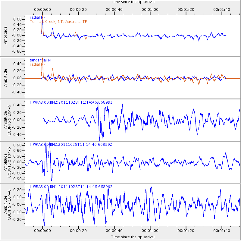
WRAB Tennant Creek, NT, Australia - Earthquake Result Viewer
*The percent match for this event was below the threshold and hence no stack was calculated.
| Earthquake location: |
Kermadec Islands Region |
| Earthquake latitude/longitude: |
-28.8/-176.1 |
| Earthquake time(UTC): |
2011/10/28 (301) 11:07:01 GMT |
| Earthquake Depth: |
50 km |
| Earthquake Magnitude: |
5.7 MB |
| Earthquake Catalog/Contributor: |
NEIC PDE/NEIC PDE-M |
|
| Network: |
II Global Seismograph Network (GSN - IRIS/IDA) |
| Station: |
WRAB Tennant Creek, NT, Australia |
| Lat/Lon: |
19.93 S/134.36 E |
| Elevation: |
366 m |
|
| Distance: |
45.7 deg |
| Az: |
269.601 deg |
| Baz: |
111.088 deg |
| Ray Param: |
$rayparam |
*The percent match for this event was below the threshold and hence was not used in the summary stack. |
|
| Radial Match: |
63.48334 % |
| Radial Bump: |
332 |
| Transverse Match: |
45.312946 % |
| Transverse Bump: |
400 |
| SOD ConfigId: |
558545 |
| Insert Time: |
2013-09-19 05:16:06.067 +0000 |
| GWidth: |
2.5 |
| Max Bumps: |
400 |
| Tol: |
0.001 |
|
Signal To Noise
| Channel | StoN | STA | LTA |
| II:WRAB:00:BHZ:20111028T11:14:46.66899Z | 6.1262016 | 5.5016955E-7 | 8.980598E-8 |
| II:WRAB:00:BH1:20111028T11:14:46.66899Z | 1.3507179 | 1.3813838E-7 | 1.0227034E-7 |
| II:WRAB:00:BH2:20111028T11:14:46.66899Z | 5.083641 | 3.007745E-7 | 5.9165174E-8 |
| Arrivals |
| Ps | |
| PpPs | |
| PsPs/PpSs | |


