You are here: Home > Network List > IU - Global Seismograph Network (GSN - IRIS/USGS) Stations List
> Station PMG Port Moresby, New Guinea > Earthquake Result Viewer
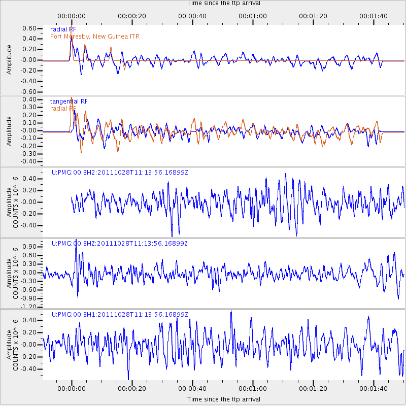
PMG Port Moresby, New Guinea - Earthquake Result Viewer
*The percent match for this event was below the threshold and hence no stack was calculated.
| Earthquake location: |
Kermadec Islands Region |
| Earthquake latitude/longitude: |
-28.8/-176.1 |
| Earthquake time(UTC): |
2011/10/28 (301) 11:07:01 GMT |
| Earthquake Depth: |
50 km |
| Earthquake Magnitude: |
5.7 MB |
| Earthquake Catalog/Contributor: |
NEIC PDE/NEIC PDE-M |
|
| Network: |
IU Global Seismograph Network (GSN - IRIS/USGS) |
| Station: |
PMG Port Moresby, New Guinea |
| Lat/Lon: |
9.40 S/147.16 E |
| Elevation: |
90 m |
|
| Distance: |
39.5 deg |
| Az: |
291.828 deg |
| Baz: |
124.325 deg |
| Ray Param: |
$rayparam |
*The percent match for this event was below the threshold and hence was not used in the summary stack. |
|
| Radial Match: |
68.48395 % |
| Radial Bump: |
400 |
| Transverse Match: |
51.63628 % |
| Transverse Bump: |
400 |
| SOD ConfigId: |
558545 |
| Insert Time: |
2013-09-19 05:16:37.648 +0000 |
| GWidth: |
2.5 |
| Max Bumps: |
400 |
| Tol: |
0.001 |
|
Signal To Noise
| Channel | StoN | STA | LTA |
| IU:PMG:00:BHZ:20111028T11:13:56.16899Z | 4.190447 | 4.4879715E-7 | 1.0710007E-7 |
| IU:PMG:00:BH1:20111028T11:13:56.16899Z | 1.2607223 | 1.6208624E-7 | 1.2856617E-7 |
| IU:PMG:00:BH2:20111028T11:13:56.16899Z | 1.9528476 | 2.0522614E-7 | 1.05090706E-7 |
| Arrivals |
| Ps | |
| PpPs | |
| PsPs/PpSs | |


